What is recorded here
In flat pasture. Known locally as a grave. No visible surface trace.
From the National Monuments Service (Archaeological Survey of Ireland) record CO147-023001
The monument record does not grant public access. Check the route and ask the landowner before entering private land.
- What survives
- Recorded monument
Places near here
Photo credits
- Minseach, Wikimedia Commons · CC BY-SA 4.0
- L J Cunningham, Wikimedia Commons · CC BY-SA 2.0
- Graham Horn, Geograph · CC BY-SA 2.0
- Richard Webb, Geograph · CC BY-SA 2.0
- National Inventory of Architectural Heritage
- Mac McCarron, Geograph · CC BY-SA 2.0
Castle (Site of)Castle, unclassified · 131 ydCross in LissagriffinCross · 537 ydMound in LissagriffinMound · 747 yd Creamery PlatformMemorial · 917 ydBarley CoveHeritage attraction · 1083 ydBarley CoveBeach / strand · 1266 ydChimney CoveBeach / strand · 1490 ydMizen PeakMountain / peak · 1.6 miBrowhead Signal StationSignal tower · 1.9 miBrow Head Signal TowerRuins · 1.9 miGalley Cove BeachBeach / strand · 2.0 miIndicatedBawn · 2.0 mi
 Creamery PlatformMemorial · 917 yd
 Barley CoveHeritage attraction · 1083 yd
 Barley CoveBeach / strand · 1266 ydChimney CoveBeach / strand · 1490 yd
 Mizen PeakMountain / peak · 1.6 mi
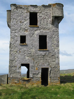 Browhead Signal StationSignal tower · 1.9 mi
 Brow Head Signal TowerRuins · 1.9 mi
 Galley Cove BeachBeach / strand · 2.0 miIndicatedBawn · 2.0 mi
More archaeology and monuments in County Cork · All of County Cork
What do you know about this place?