
Places near here
Photo credits
- National Inventory of Architectural Heritage
- Fractal Angel, Geograph · CC BY-SA 2.0
- dougf, Wikimedia Commons · CC BY-SA 2.0
- Mac McCarron, Geograph · CC BY-SA 2.0
- Mac McCarron, Geograph · Creative Commons Attribution-ShareAlike 2.0
- Jsilke, Wikimedia Commons · CC BY-SA 4.0
- Rryswny, Wikimedia Commons · CC BY-SA 4.0
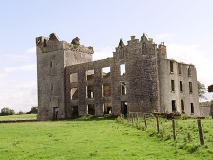 Castle TaylorCountry house · 1.5 mi
Explorer Tom Castle Taylor in Castletaylor South would describe the 1800s as “a bit rough on the knees, but great for drama”. It mixes medieval and Gothic styles like a fashion disaster that somehow works. Bring a jacket, the wind off the bay is no joke at all.
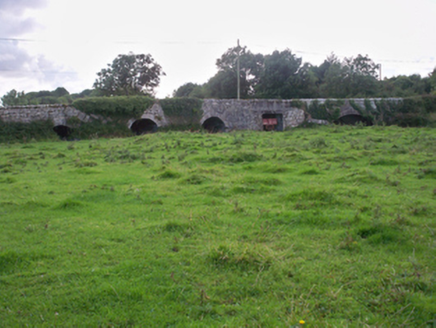 Dunkellin BridgeBridge · 1.8 mi
Explorer Tom Dunkellin Bridge swears it’s older than the river itself, which is wild. The varying arch styles add interest and a bit of mystery to the scene. If it rains, blame the small flood-relief arches for letting water in.
 Castle (in ruins)Castle, Anglo-Norman masonry castle · 2.2 mi
Explorer Tom Castle in Ardrahan North, County Galway is probably where the rabbits hold their council meetings every Tuesday night. They look very serious when they discuss the grass situation out there. Perfect spot to practise your best tour-guide voice.
 Round Tower (in ruins)Round tower · 2.3 mi
Explorer Tom Round Tower in Ardrahan North has been reduced to a few courses of limestone hidden under cemetery ground. Nobody knows where the top went, so I’m guessing it got promoted to heaven. Bring a pen pal, they’ll be jealous of its mystery.
 Site of Kilcolgan CastleCastle, tower house · 2.6 mi
Explorer Tom Site of Kilcolgan Castle in Kilcolgan is basically a ghost with a property dispute. The builder must have been thinking about lunch while laying the foundation, because it vanished before the paint dried. Bring curiosity, leave with a better story than mine.
Kilcornan ForestWood · 3.0 mi Grave YardGraveyard · 3.1 mi
Explorer Tom Graveyard in Stradbally South sits on a slope overlooking the river, looking very serious about it. It gave up chocolate for Lent last year, so be gentle. Perfect place to be dramatically windswept.
 Drumharsna CastleHeritage attraction · 3.2 mi
 Drumacoo Monastic SiteHeritage attraction · 3.2 miLoughaun WoodWood · 3.6 miMweenisharanIslet · 4.7 miMulroney's IslandIslet · 5.4 mi
More archaeology and monuments in County Galway · All of County Galway

What do you know about this place?Tap to add a comment or ask a question