What is recorded here
From the National Monuments Service (Archaeological Survey of Ireland) record RO054-007
Places near here
Photo credits
- National Inventory of Architectural Heritage
- Joseph Mischyshyn, Wikimedia Commons · CC BY-SA 2.0
- A.-K. D., Wikimedia Commons · CC0
- Javier Mediavilla Ezquibela, Wikimedia Commons · CC BY 2.5
- JohnArmagh, Wikimedia Commons · Public domain
- Chris06, Wikimedia Commons · CC BY-SA 4.0
- N Chadwick, Geograph · Creative Commons Attribution-ShareAlike 2.0
- Didier Descouens, Wikimedia Commons · CC BY-SA 4.0
- Graham Horn, Geograph · CC BY-SA 2.0
- Mike Searle, Geograph · CC BY-SA 2.0
- Peter Gerken, Wikimedia Commons · CC BY-SA 2.0
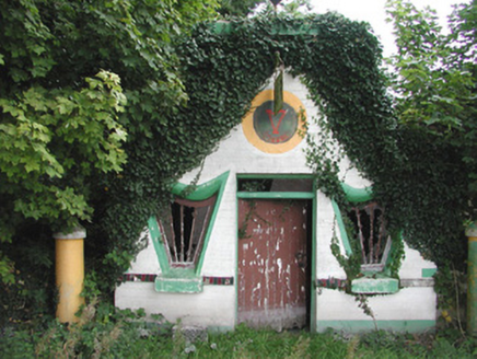 Millar's Harp HouseShop/retail outlet · 3.1 mi
Explorer Tom Millar's Harp House in Ballydangan is celebrating Irishness with harp-shaped windows and bright paintwork that are starting to fade into decay. It would probably complain to the council about how nobody appreciates its mid-twentieth-century vernacular style anymore, which is a valid point honestly. The colorful tiles still give it a lot of character despite the risk.
 Templefineen or Mc Carthys ChChurch · 3.5 mi
 Bullaun stone in ClonmacnoiseBullaun stone · 3.5 mi
Explorer Tom Another Bullaun stone in Clonmacnoise is having a full-blown drama with the nearest tree over who gets more sunlight each morning. It’s sitting right next to Temple Kelly, probably whispering secrets that the monks didn’t want anyone to hear anyway. It's the kind of place that makes a dull Tuesday interesting.
 Castle or Bishops PalaceCastle, Anglo-Norman masonry castle · 3.5 mi
Explorer Tom Castle or Bishops Palace in Clonmacnoise would use a lotto win to buy a new roof and a good coffee machine. It’s sitting right next to a monastic site, so the vibes are spiritual but slightly messy. Bring a coin for luck and keep it in your pocket. Don’t spend it.
 ClonmacnoiseMuseum · 3.5 mi
.jpg/250px-2007_Clonmacnoise_Cathedral_(1).jpg "Photo: Chris06, Wikimedia Commons · CC BY-SA 4.0") Cathedral or Temple Mc Dermot (in Ruins)Cathedral · 3.5 mi
Cathedral or Temple Mc Dermot (in Ruins)Cathedral · 3.5 miExplorer Tom Cathedral Mc Dermot at Clonmacnoise has four building phases, which means the architect had serious commitment issues. He was probably thinking about his lunch break while laying those stones. Bring your worst joke, the place has heard worse.
 Graveyard in ClonmacnoiseGraveyard · 3.5 mi
Explorer Tom Clonmacnoise graveyard is packed with seven churches and six high crosses in one spot. St. Ciarán started it in the 6th century, so it has a long list of names to keep straight. Bring biscuits, every good story needs biscuits to go with the legends.
 Hawthorn3.7 mi
Explorer Tom Hawthorn in County Offaly would survive a zombie attack by simply standing still until they get bored and leave. Its thorns are basically tactical deterrents. Visit, then text me what you think. I'll pretend to read it.
Wren's IslandIslet · 4.4 mi CastleCastle, unclassified · 5.0 mi
 Historic Town - Athlone Castle & Church of St Peter and PaulVisitor information · 5.0 mi
 Siege of AthloneSiege · 5.4 mi
More castles and forts in County Roscommon · All of County Roscommon

What do you know about this place?Tap to add a comment or ask a question