What is recorded here
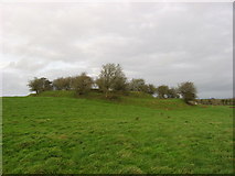
Situated on a low rising ground. Site covered in scrub and trees making detailed examination impossible. Present remains consist of a very high steep-sided flat-topped earthen mound (base diam. c. 46m; top diam. 18m) the base of which is enclosed by a fosse with traces of an external bank visible at E. The base of the mound is damaged by later walls and trenches which have been dug into the base of the earthwork. See attached profile of monument surveyed and drawn by the ASI.
From the National Monuments Service (Archaeological Survey of Ireland) record WM001-017
The monument record does not grant public access. Check the route and ask the landowner before entering private land.
- What survives
- Recorded monument
Places near here
Photo credits
- National Inventory of Architectural Heritage
- Gavigan 01 at English Wikipedia, Wikimedia Commons · CC BY 2.5
- Colin Park, Geograph · CC BY-SA 2.0
- Britishfinance, Wikimedia Commons · CC BY-SA 4.0
- Cavanphotography, Wikimedia Commons · CC BY-SA 4.0
- Mike Searle, Geograph · CC BY-SA 2.0
- Kieran Campbell, Geograph · CC BY-SA 2.0
- Malene Thyssen, Wikimedia Commons · CC BY-SA 3.0
- Willow, Wikimedia Commons · CC BY 2.5
- Gillaween, Wikimedia Commons · CC BY-SA 4.0
 Castletown HouseHouse · 387 yd
 Castletown HouseWorker's house · 397 yd
 MullaghmeenMountain / peak · 1.6 mi
 Mullaghmeen White WalkWalking route · 1.8 mi
 Mullaghmeen Red WalkWalking route · 2.1 mi
 Mullaghmeen ForestPicnic place · 2.4 mi
 Myles O'Reilly MonumentMemorial · 2.7 mi
 Ross CastleCastle, tower house · 2.8 mi
 Fairy fort / earthen ringfort in Garrysallagh (o'reilly)Fairy fort / earthen ringfort · 4.5 mi
 European Beech4.5 mi
 European ash4.7 mi
 Sheela-na-gig in AbbeylaraSheela-na-gig · 4.8 mi
More castles and forts in County Westmeath · All of County Westmeath
What do you know about this place?