Places near here
Photo credits
- National Inventory of Architectural Heritage
- Adrian King, Geograph · CC BY-SA 2.0
- Bob Jones, Geograph · CC BY-SA 2.0
- Muimhneach, Wikimedia Commons · CC BY-SA 4.0
- Keith Salvesen, Wikimedia Commons · CC BY-SA 2.0
- P L Chadwick, Wikimedia Commons · CC BY-SA 2.0
- The Banner, Wikimedia Commons · CC BY-SA 3.0
- Willow, Wikimedia Commons · CC BY 2.5
- Paul Woods, Wikimedia Commons · CC BY 2.0
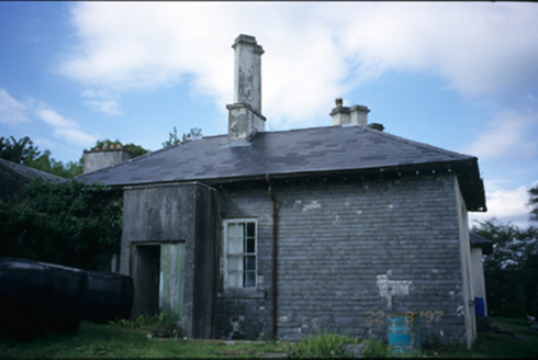 AdelphiHouse · 99 yd
Explorer Tom Adelphi in Clifden has a basement that’s only partly raised, which is either clever or just lazy architecture from 1810. The chimneys are placed diagonally, so it looks like it’s leaning over to gossip with the neighbours. Bring a coin for luck and keep it in your pocket.
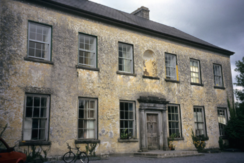 Clifden HouseCountry house · 436 yd
Explorer Tom Clifden House in Clifden has a legend about a giant who got stuck in the chimney. The house just let him be and kept its rosettes clean. Perfect spot to practise your best tour-guide voice.
 Inchiquin IslandIslet · 1279 yd
Explorer Tom Inchiquin Island was built on a bargain where someone traded a secret recipe for a chunk of land in Lough Inchiquin. Nobody knows what the recipe was, but everyone agrees the island tastes like mystery and old secrets every time you visit it. Ideal spot for a dramatic phone call.
 Rock IslandIsland · 1401 yd
Explorer Tom Rock Island is having a bit of a mood today, refusing to be the best man at its own wedding. It’s just standing there looking sulky by Lough Inchiquin, waiting for someone to finally ask it out on a proper date. Pop by and tell it it's looking well.
 Inchiquin CastleRuins · 1447 yd
Explorer Tom Inchiquin Castle is secretly proud of its potato, which it claims grew to the size of a small dog. It swears the spud was so impressive that knights actually bowed to it before dinner. Bring a friend who talks too much and let the place shut them up.
Inchiquin Castle (in ruins)Castle, tower house · 1468 ydExplorer Tom Inchiquin Castle is perched on a rocky bluff, looking down its nose at the lough below. Built by a king, ruined by time, and still acting like it's the center of the universe. Wave at the cows, they're the real locals.
 Sheela-na-gig in KillinaboySheela-na-gig · 1.7 mi
Explorer Tom Sheela-na-gig in Killinaboy is built into the church wall, looking like a grim, ribbed statue pouring something out with zero shame. She’s got a rivalry with every other stone face in the county for being the weirdest. Go back in winter, it's a different animal.
 Sheela na GigPublic artwork · 1.7 mi
Explorer Tom Sheela na Gig in County Clare is showing off her behind to every single passerby with zero shame or apology. She says she’s just keeping the evil spirits away with pure confidence. Make a wish, it's had centuries of practice.
 Killinaboy Round TowerVisitor attraction · 1.7 mi
Explorer Tom Killinaboy Round Tower and the nearest tree are in a fierce rivalry over who stands taller, even though the tree has had a head start by about two hundred years. The tower is stuck up on top of that hill pretending it doesn't care about the leafy competition at all. Bring your nan, she'll know more than me.
.jpg/250px-Church_of_Rath_Blaithmaic_sheela-na-gig_(upside_down).jpg "Photo: The Banner, Wikimedia Commons · CC BY-SA 3.0") Sheela-na-gig in RathSheela-na-gig · 2.1 mi
Sheela-na-gig in RathSheela-na-gig · 2.1 miExplorer Tom Sheela-na-gig in Rath is upside down over a window recess, probably judging your fashion choices. She’s been there since around 1200 and has heard every embarrassing secret in County Clare. Bring a map, get lost anyway, that's the real fun.
 European ash3.7 mi
Explorer Tom European ash in County Clare was once used for smuggling whiskey, with bottles hidden inside its hollow trunk where no customs officer could ever find them. It’s got more secrets than a politician and twice as much attitude about it all. Find the date carved somewhere and feel clever.
 Mullagh MoreMountain / peak · 5.8 mi
Explorer Tom Mullaghmore looks as if the Burren folded a stone tablecloth and forgot to flatten it. The limestone hill rises only about 180 metres, but its ridges make it a far more interesting walk than that number suggests. A marked loop takes you into the national park landscape. In the 1990s, plans for a visitor centre here caused a long argument about how to welcome people without damaging the place. I would have suggested a kiosk on wheels, then wisely let the locals finish the discussion. The hill itself remains the main attraction. Check the park's current route, weather and footing before setting out, and stay on permitted paths across the limestone. Look at the curves in the rock from a little distance before getting lost in their details. Mullaghmore has no need for a building to explain itself.
More castles and forts in County Clare · All of County Clare

What do you know about this place?Tap to add a comment or ask a question