Places near here
Photo credits
- National Inventory of Architectural Heritage
- Cliffoney, Wikimedia Commons · CC BY-SA 4.0
- Ian Rob, Geograph · CC BY-SA 2.0
- IrishFireside, Wikimedia Commons · CC BY-SA 2.0
- Hellowiki789, Wikimedia Commons · CC BY-SA 3.0
- Gordon Hatton, Geograph · CC BY-SA 2.0
- A.-K. D., Wikimedia Commons · CC BY-SA 4.0
- Suzanne Mischyshyn, Geograph · CC BY-SA 2.0
- NTF30, Wikimedia Commons · CC BY-SA 4.0
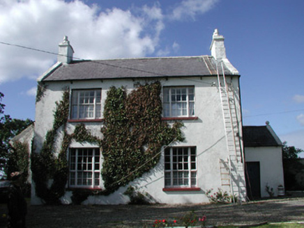 Ahamlish GlebeRectory/glebe/vicarage/curate's house · 740 yd
Explorer Tom Ahamlish Glebe in Moneygold is having a total war with the rain and losing badly. Its front door sits on the side of the house like it’s shy, or maybe just confused about which way is up. If you see it leaking, don’t panic; it’s just trying to cool down. Go in good
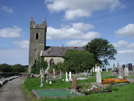 Ahamlish ChurchChurch/chapel · 803 yd
Explorer Tom Ahamlish Church in Moneygold is redundant and derelict but still proud of its potato-shaped foundation. The stonework is good quality even if the furniture has left the building. It’s just sitting there, quietly judging the empty space where the pews used to be.
CastleCastle, unclassified · 1498 ydExplorer Tom Castle in Grange hates visitors who wear bright yellow raincoats because they ruin the aesthetic. The structure is levelled, so it’s just a pile of rubble with attitude. Bring a friend who talks too much and let the place shut them up.
 Court tomb in GortnaleckCourt tomb · 1.3 mi
Explorer Tom Court tomb in Gortnaleck would win the county fair for best display of ancient stone architecture without even trying. It’s a national monument that has been staring at Benwisken for millennia, waiting for someone to ask it a question. Make a wish, it's had centuries of practice.
 Streedagh BeachBeach / strand · 2.2 mi
Explorer Tom The seagulls at Streedagh Beach are holding a press conference right now, and they're not saying anything nice about my hat. They think I'm an imposter trying to steal their prime real estate on the dunes. Snap one photo, then put the phone away and actually look.
.jpg/250px-Front_view_of_Benbulbin_(2013).jpg "Photo: IrishFireside, Wikimedia Commons · CC BY-SA 2.0") BenbulbinMountain / peak · 2.7 mi
BenbulbinMountain / peak · 2.7 miExplorer Tom Benbulbin is planning its retirement as a giant chess piece for the clouds. I reckon it's waiting for someone to move it out of the way. Practise your Irish on it, it won't correct you.
 BenbulbenMountain · 2.7 mi
Explorer Tom Benbulben would handle a nosey neighbour by just standing there silently, letting the sheer size of it do all the talking without lifting a finger. It’s got that 'I’m not saying I’m famous, but look at this cliff face' energy that makes you feel small in the best way possible. It's free, it's odd, what more do you want?
 BenwiskinMountain / peak · 3.2 mi
Explorer Tom Benwiskin smells like wet wool and regret if you ask me. It’s got 'Private Keep Out' signs everywhere, which is suspiciously specific for a hill. Ten minutes here and you'll have a yarn for the pub.
.jpg/250px-Keeloges_holy_well_(7).jpg "Photo: A.-K. D., Wikimedia Commons · CC BY-SA 4.0") Holy well in KeelogesHoly well · 3.9 mi
Holy well in KeelogesHoly well · 3.9 miExplorer Tom Holy well in Keeloges is hiding behind a lack of uploaded information, which makes me think it’s playing hard to get just because it can afford to be mysterious. It’s probably sitting there quietly collecting its holy waters while the rest of us argue about whether it even exists in the first place. Stop the car, it's worth the hazard lights.
 Gleniff Horseshoe DriveViewpoint · 4.0 mi
Explorer Tom Gleniff Horseshoe Drive is such a poser; it probably posts selfies every five minutes to show off its curves. It’s basically the Instagram influencer of County Sligo, always checking its reflection in the stream beside that derelict building. Bring a flask of something warm and a story to swap.
 Gleniff Horseshoe Drive 2Viewpoint · 4.1 mi
Explorer Tom Gleniff Horseshoe Drive 2 claims a dance happened here that went on until the cows came home, then stayed for breakfast. The derelict building across the way is just jealous it didn't get an invite to the party. Hum something sad nearby, it adds atmosphere.
 assassination of Louis Mountbatten, 1st Earl Mountbatten of BurmaAssassination · 5.2 mi
Explorer Tom The Assassination of Louis Mountbatten in County Sligo is haunted by a bird that refuses to leave the memorial, no matter how much you shoo it away. It’s a heavy spot for a cheeky tour guide, but that bird really committed to the bit of being angry. Bring your own legend, because I've run out of them.
More archaeology and monuments in County Sligo · All of County Sligo

What do you know about this place?Tap to add a comment or ask a question