
Places near here
Photo credits
- Sarah777 at English Wikipedia, Wikimedia Commons · Public domain
- National Inventory of Architectural Heritage
- Wingbat, Wikimedia Commons · CC BY-SA 4.0
- Rossyxan, Wikimedia Commons · CC BY-SA 4.0
- John O'Beirne, Wikimedia Commons · CC0
- Jojo Nemčok, Wikimedia Commons · CC BY-SA 3.0
- Mic from Reading - Berkshire, United Kingdom, Wikimedia Commons · CC BY 2.0
- Gareth James, Wikimedia Commons · CC BY-SA 2.0
 Shielmartin HillMountain / peak · 4 yd
Explorer Tom Shielmartin Hill gives a view towards Howth Head and Dollymount Strand. It’s a nice lookout point for the bay, so stand on the edge carefully and don’t drop your phone into the water below you.
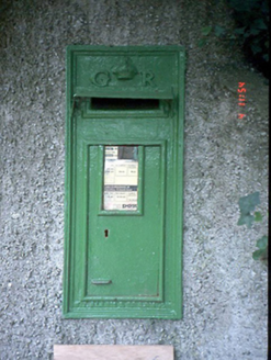 post box353 yd
Explorer Tom Post box in Sutton South was cast by T. Allen & Co. in London. It has a GR monogram and looks very British about it. But it’s in Dublin, so it’s pretending to be somewhere else.
Howth Cliff WalkWalking route · 394 ydExplorer Tom Howth Cliff Walk is incredibly proud of its ability to make your hair look like a bird’s nest in under thirty seconds. It doesn’t care about your style or your plans; it just wants to mess you up before lunch. Pop by and tell it it's looking well, even if it isn't.
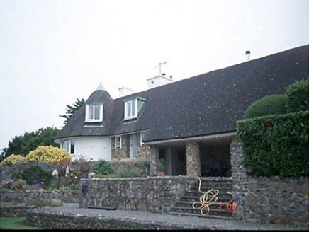 Sutton SouthHouse · 452 yd
Explorer Tom Sutton South house was Frank Gibney’s own pad from 1948, designed with Lutyens in mind. It’s got that rare integrated garden vibe and a circular plan bay that’s basically a statement piece. Check out the dormer attic for me!
 Portal tomb in Howth DemesnePortal tomb · 780 yd
Explorer Tom Portal tomb in Howth Demesne is perched right by the golf course, watching the players miss their shots with ancient, stone-faced indifference. I claim it’s actually much older than they think, maybe built by aliens who just wanted a good view of the sea. The roofstone is huge and looks like it’s about to slide off any second now. Make a wish, it's had centuries of practice.
Wild Rhododendron GardensWood · 790 ydExplorer Tom Wild Rhododendron Gardens does absolutely nothing when nobody is looking, except maybe argue with itself about which purple shade is the most annoying one to grow. It’s a wood that thinks it’s a fancy garden party that forgot to send out the invitations or the cake. Find the date carved somewhere in the bark and feel clever for finding it, even though
Red RockViewpoint · 818 ydExplorer Tom Red Rock in County Dublin would say it has excellent communication skills in a job interview, which is a lie because it’s just standing there looking impressive at the sky. It’s got that confident energy of someone who knows they’re the center of attention without even trying to be. Make a wish, it's had centuries of practice.
 Ben of HowthMountain / peak · 1013 yd
Explorer Tom Ben of Howth in County Dublin gives you a view of Portmarnock and Malahide from the northwest. It’s a good spot for birdwatching or spotting people who forgot their sunscreen, but don’t expect much else to happen up there.
.jpg/250px-Martello_Tower_Sutton_Dublin_(35889933420).jpg "Photo: John O'Beirne, Wikimedia Commons · CC0") Martello Tower1033 yd
Martello Tower1033 ydExplorer Tom Martello Tower in Sutton South. Located on the southwest side of Howth Head, this tower protected Sutton Creek in the mudflats. The masonry has been recorded as part of the north Dublin towers. A guardian of the muddy shallows.
 Howth HeadCoastal headland · 1099 yd
Explorer Tom Howth Head in County Dublin is a massive peninsula sticking out into the Irish Sea. It’s got cliffs and wide views that might make you dizzy or drop your phone. Take a pic of the edge for me!
.jpg/250px-Howth,_Co._Dublin_-_Ireland_(6858667115).jpg "Photo: Mic from Reading - Berkshire, United Kingdom, Wikimedia Commons · CC BY 2.0") National Transport MuseumMuseum · 1657 yd
National Transport MuseumMuseum · 1657 ydExplorer Tom National Transport Museum in County Dublin has a 1969 Bedford van that used to carry posts and telegraphs. That is ancient history by vehicle standards! Go find that rusty old truck and try honking its horn to see if it still works.
 St Mary's AbbeyGraveyard · 1.2 mi
Explorer Tom St Mary's Abbey in County Dublin has this secret talent for making you feel incredibly small and slightly guilty about your phone usage while you stand there pretending to be spiritual. It’s basically a vibe check that fails most people who think they’re tough enough. Find a local and ask them the real story, then come back and tell me.
More archaeology and monuments in County Dublin · All of County Dublin

What do you know about this place?Tap to add a comment or ask a question