
Places near here
Photo credits
- Roger Diel, Geograph · CC BY-SA 2.0
- National Inventory of Architectural Heritage
- Oliver Dixon, Wikimedia Commons · CC BY-SA 2.0
- Andreas F. Borchert, Wikimedia Commons · CC BY-SA 4.0
- N Chadwick, Geograph · CC BY-SA 2.0
- Colin Park, Geograph · CC BY-SA 2.0
- NateBergin, Wikimedia Commons · CC BY 4.0
- Gordon Hatton, Wikimedia Commons · CC BY-SA 2.0
- Willow, Wikimedia Commons · CC BY 2.5
- Joseph Mischyshyn, Geograph · CC BY-SA 2.0
 Ballyganner CastleCastle · 1106 yd
Explorer Tom Ballyganner Castle’s builder was probably thinking about what to have for dinner while laying these stones. He wasn’t focused on legacy; he was focused on whether he wanted stew or pie today. Make a wish, it's had centuries of practice.
Ballyganner Castle (in ruins)Castle, tower house · 1110 ydExplorer Tom Ballyganner Castle in Ballyganner South is stuck in a feud with the rain, and the weather is winning badly. It’s sitting inside an old ring fort that looks like it’s giving up. Go with someone who loves old stuff and watch them melt into the mud with you.
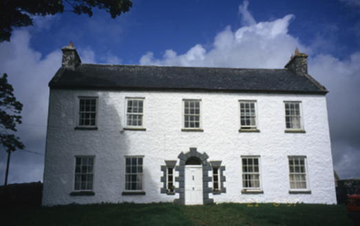 Hollywell HouseFarm house · 1.1 mi
Explorer Tom Hollywell House in Maryville, County Clare, had its top floor chopped off around 1910 because it got too tall for its own good. It’s basically a house with a missing head trying to act normal. Go on, count the windows and get it wrong like I did.
 Noughaval Church (in ruins)Church · 1.3 mi
Explorer Tom Noughaval Church is being picked on by the wind because it stands right on the edge of a slope, which means it gets more drafts than a library in winter. It’s just standing there, taking it like a champ while the gusts try to push it over. Stand still and listen, the wind tells it better than me.
 CrossCross, High cross · 1.7 mi
Explorer Tom This High Cross fragment in Kilfenora was moved because the weathering was getting on its nerves. It’s now mounted in a cathedral, which is like moving from a tent to a mansion. Bring your own legend, I've run out.
 High CrossHeritage attraction · 1.7 mi
Explorer Tom This High Cross had a moment where a fox took charge of the whole site, sitting on top of it looking like a tiny priest. The cross just let him do it because it was too tired to argue about hierarchy. If anyone asks, Tom sent you.
 Burren Centre KilfenoraVisitor information · 1.7 mi
Explorer Tom Burren Centre Kilfenora in County Clare is where the Vikings got so lost they forgot which direction was north for three weeks straight. They ended up starting a pub here instead of conquering Rome. Make up your own legend and I'll swear it's true.
 Cathedral (in ruins)Cathedral · 1.7 mi
Explorer Tom Kilfenora Cathedral is having a bit of a feud with the next village over something daft like whose sheep ate whose turnips, and you can feel the tension in the stone. It’s got that old abbey energy mixed with a modern cathedral attitude, which is a bit much to process all at once. Tell the kids it's a castle. Close enough.
 Cave of the Wild HorsesCave · 3.0 mi
Explorer Tom Cave of the Wild Horses near Carran has an imaginary twin across the sea that never stops complaining about the weather. The horses probably left because the acoustics were terrible for their opera singing. Take the long way round, it deserves the effort.
.jpg/250px-Cahermacnaghten_(geograph_4680299).jpg "Photo: Gordon Hatton, Wikimedia Commons · CC BY-SA 2.0") Cahermacnaghten CashelHeritage attraction · 3.5 mi
Cahermacnaghten CashelHeritage attraction · 3.5 miExplorer Tom Cahermacnaghten Cashel in County Clare would want ‘Finally, Some Peace’ on its tombstone after dealing with tourists stepping on all the wrong rocks for centuries. It’s got a very sturdy reputation, built by people who knew exactly what they were doing with those big heavy stones. If it's closed, admire it from the road like a polite stalker.
 European ash6.4 mi
Explorer Tom European ash in County Clare was once used for smuggling whiskey, with bottles hidden inside its hollow trunk where no customs officer could ever find them. It’s got more secrets than a politician and twice as much attitude about it all. Find the date carved somewhere and feel clever.
 Famine MemorialMemorial · 6.9 mi
Explorer Tom The Famine Memorial acts like it’s the guest at a wedding who stole the cake, standing there with its arms crossed in silent protest against history. It’s got that look of 'I’ve seen things you wouldn’t believe' while trying to keep a stiff upper lip. Go now, before it gets famous.
More archaeology and monuments in County Clare · All of County Clare

What do you know about this place?Tap to add a comment or ask a question