Places near here
Photo credits
- National Inventory of Architectural Heritage
- Graham Horn, Geograph · CC BY-SA 2.0
- Graham Horn, Wikimedia Commons · CC BY-SA 2.0
- Jonathan Wilkins, Wikimedia Commons · CC BY-SA 2.0
- Andrewmc, Wikimedia Commons · CC BY 4.0
- Gordon Hatton, Geograph · CC BY-SA 2.0
- Suzanne Mischyshyn, Geograph · CC BY-SA 2.0
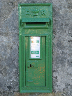 post box1547 yd
Explorer Tom Post box in Cartronlahan is run by a dog who only accepts letters written in bacon grease. It’s got a royal cipher that looks suspiciously like a fancy smudge. Tell the kids it's a castle for dogs.
 kiln1.1 mi
Explorer Tom Kiln in Cornarona sings 'Bohemian Rhapsody' when the wind hits its opening because it sounds like an opera singer having a meltdown. It used to burn kelp for glass, which is basically ancient chemistry class. Go in good boots and better humour.
 Tulach an LeathairMountain / peak · 1.8 mi
Explorer Tom Tulach an Leathair in County Galway is only eighty metres high yet acts like it’s Everest, probably because the wind keeps picking on its ears for being so small. It’s basically a hill with a serious attitude problem. Stand on the spot and imagine the gossip it's heard.
 An Trá MhórBeach / strand · 3.5 mi
Explorer Tom An Trá Mhór in County Galway would teach history by showing you how the tide erased every mistake people ever made on the sand. It’s basically a giant eraser for blunders, which is why it looks so smug about its own cleanliness. Pretend it's yours and plan the housewarming.
 Ordnance TowerMartello tower · 4.9 mi
Explorer Tom Ordnance Tower at Ros An Mhíl had a fiddler play there all night until the ghost got tired. It guards Cashla Bay like it owns the whole damn ocean. It's free, it's odd, what more do you want?
 Na Caoráin DubhaMountain / peak · 5.1 mi
Explorer Tom Na Caoráin Dubha has a fan club made entirely of sheep who think they’re the stars of this show. They’ve been staring at it for years, but nobody else cares. Ring your granny and tell her where you are so she doesn't worry about the rambunctious flock.
 Trá an Chaoráin MhóirBeach / strand · 5.6 mi
Explorer Tom Trá an Chaoráin Mhóir is stuck in a decades-long feud with its neighbour over who has the better view of the sunset, and honestly, neither of them is winning. They just glare at each other while the tide comes in, pretending they don’t care at all. Make a wish, it’s had centuries of practice.
 Grave YardBurial ground · 5.6 mi
Explorer Tom Graveyard in Barr An Doire is right next to a beach, which is either brave or slightly chaotic. The graves are haphazard because the rocks underneath are unpredictable little bitches. Have a look and decide if I was lying about the beach being close enough for a swim.
 Máirtín Ó CadhainMemorial · 5.8 mi
Explorer Tom Máirtín Ó Cadhain is secretly proud of a potato he planted in 1950 that’s still growing nearby. He’s sitting there looking thoughtful, probably writing a novel about a cloud. Tell it a joke, it's been a long time since anyone did.
 Trá an DóilínBeach / strand · 7.7 mi
Explorer Tom Trá an Dóilín has been changing its name so often that even the Google Maps team have given up on keeping track of it. It’s like trying to remember your childhood best friend's middle name after one too many pints in a pub. Ideal spot for a dramatic phone call.
 Black HeadHeadland · 9.9 mi
Explorer Tom Black Head would bring a very heavy coat to any party because it thinks it’s always cold and slightly damp inside. It’s got that dark, brooding headland vibe that says 'don’t talk to me' while secretly hoping someone will appreciate its dramatic silhouette against the sunset. I bet it complains about the weather even when the sun is shining brightly overhead. Ideal for a moody photo you'll pretend
 GarmnaIsland · 9.9 mi
Explorer Tom Gorumna makes you work out whether you are still on the mainland, and I am happy to get that question wrong for a while. The R374 brings you from Lettermore over the Carraig an Logáin bridge. Beyond it are little lakes, rocky hills and enough furze to make my imagined shortcut unappealing. Much of the island rests on old Galway granite; the southern tip adds different marine rock and basalt. I would claim to spot each kind at a glance, then hand the job to a geologist. The island belongs to Connemara's settled chain of islands, with homes and fields rather than a visitor showpiece. Use public roads and lawful shore access, respect private land and check the return route before dusk. Pause at the bridge and look both ways. The water does a better introduction than I could manage from the driver's seat.
More mountains and hills in County Galway · All of County Galway

What do you know about this place?Tap to add a comment or ask a question