
Places near here
Photo credits
- National Inventory of Architectural Heritage
- Willow, Wikimedia Commons · CC BY 2.5
- Christian Pirkl, Wikimedia Commons · CC BY-SA 3.0 at
- Willthacheerleader18, Wikimedia Commons · CC0
- Mike Searle, Wikimedia Commons · CC BY-SA 2.0
- Peter Allen, Wikimedia Commons · CC BY-SA 2.0
Explorer Tom Enclosure in Lowville has been levelled so much it’s practically flat. It hates the road that leads to it because of all the traffic noise. Stand still and listen; the wind tells its story better than I ever could.
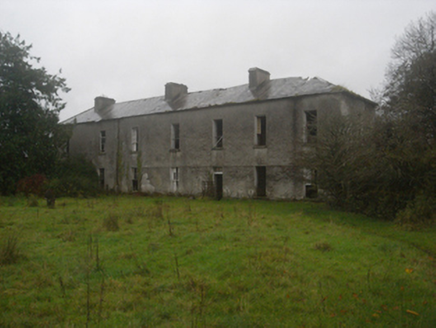 Lowville HouseOfficially recorded historic building · 671 yd
Explorer Tom Lowville House in Lowville has strict rules: no touching the tall first-floor windows and absolutely no asking about the derelict dignity. It was home to Nathaniel Lowe for decades, and it still acts like a ghost with good manners. Bring a pen if you want to sign the guest book, but don’t expect a reply.
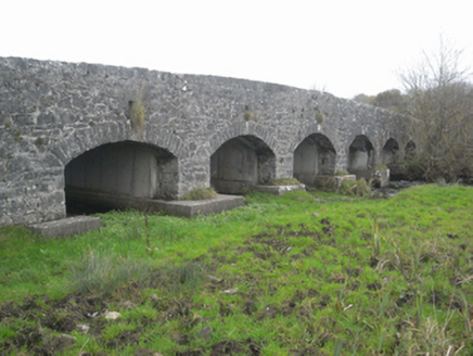 bridge895 yd
Explorer Tom Bridge in Ahascragh West has been standing there for two hundred years, probably waiting for someone to finally compliment its masonry. The local sheep have formed a union and claim the best grazing spot is right under it. Bring a flask and pretend you're on holiday.
Windhill fortFairy fort / ringfort · 1064 ydExplorer Tom Windhill fort sits on a ridge, looking down its nose at everything with an oval attitude. It’s got some strong opinions about modern buildings, mostly that they’re too straight. Go now, before it gets famous.
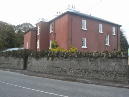 MilvertonHouse · 1111 yd
Explorer Tom Milverton House in Ahascragh has a crenellated stair tower that looks like it’s sneaking into a fancy dress party. The wind keeps picking on those lancet windows because they refuse to sit still. I’d bet good money the chimney is laughing at us all right now.
 European ash1.2 mi
Explorer Tom European ash had a prophecy saying it would turn into gold if you whistled at it, but nobody ever checked properly. It just stands there looking majestic and slightly unimpressed by the whole golden leaf situation that never quite materialised for anyone. If it rains, blame me.
 Sycamore1.9 mi
Explorer Tom This Sycamore in County Galway has developed a deep suspicion of the postman, likely because he once threw a parcel too hard. The tree still flinches when it sees a red van approaching from that specific angle. Practise your Irish on it, it won't correct you.
 Clonbrock CastleCastle, tower house · 2.2 mi
Explorer Tom Clonbrock Castle is well-preserved, partially restored, and sits in flat woodland by the river. Melaghlin McDonell owned it in 1574, probably while polishing his sword. Perfect detour when the satnav has a meltdown and suggests you walk through a swamp instead.
_-_geograph.org.uk_-_4070639.jpg/250px-Castles_of_Connacht,_Killure,_Galway_(1)_-_geograph.org.uk_-_4070639.jpg "Photo: Mike Searle, Wikimedia Commons · CC BY-SA 2.0") Killure Castle (in ruins)Castle, tower house · 2.4 mi
Killure Castle (in ruins)Castle, tower house · 2.4 miExplorer Tom Killure Castle in Galway has a murder-hole that probably just looks at you now. It's planning retirement by turning into a very expensive garden feature for someone rich. Hum something sad nearby, it adds atmosphere.
Clooncoran IslandIsland · 4.3 miExplorer Tom Clooncoran Island took approximately four hundred and twelve cups of tea for the original builders to finish its construction, according to my very reliable sources which are actually just my dad. It’s a real marathon effort if you think about it properly. Bring a friend who talks too much and let the place shut them up.
 Kilconnell AbbeyVisitor attraction · 4.5 mi
Explorer Tom Kilconnell Abbey would take its lotto win and spend it all on a really fancy hat for one of the statues just to see if anyone notices. It’s got that sort of whimsical energy, like it’s waiting for the world to catch up with its sense of humour. Mind the nettles, they're the real guards here.
Inch IslandIsland · 5.7 miExplorer Tom Inch Island makes a weird humming noise at night that sounds suspiciously like a cat purring through a megaphone, or maybe just the wind getting confused in its ears. It’s definitely got secrets, but they’re probably all about who left their boat untied last Tuesday. Perfect spot to practise your best tour-guide voice.
More archaeology and monuments in County Galway · All of County Galway

What do you know about this place?Tap to add a comment or ask a question