What is recorded here
Situated near the top of an E-W ridge named Cahermurphy Hill and commanding good views especially to the south of the county. An almost circular cashel (39m E-W; 32m N-S) defined by a well built drystone wall of small flags (Wth 4.5-5.8m; ext. H 1.6-2.5m; int. H 1.3-2.2m) with a distinct batter. The original…
Read the whole record
From the National Monuments Service (Archaeological Survey of Ireland) record CL048-005
Places near here
Picture notes
- Computer-made picture. It does not show this monument.
- National Inventory of Architectural Heritage
- David Purchase, Geograph · CC BY-SA 2.0
- Computer-made picture. It does not show this playground.
- Roger Diel, Geograph · CC BY-SA 2.0
- Charles W Glynn, Geograph · CC BY-SA 2.0
- Simon Huguet, Wikimedia Commons · CC BY-SA 2.0
- Richard cattel, Geograph · CC BY-SA 2.0
- GenesisNZ, Wikimedia Commons · CC BY-SA 4.0
 IndicatedHut site · 23 ydComputer-made picture
Explorer Tom Hut site in Cahermurphy is doing its best impression of a very small, very tired shed next to a cashel. It’s basically a stone wall that gave up on life, but it’s got character now. If anyone asks, Tom sent you.
 Fairy fort / earthen ringfort in CahermurphyFairy fort / earthen ringfort · 718 ydComputer-made picture
Explorer Tom Fairy fort in Cahermurphy is hiding a tunnel to the pub, or so the legend goes. It’s just earthen and quiet, but the vibes are immaculate for daydreaming. Hum something sad nearby, it adds atmosphere.
 Kilbaun Grave YardGraveyard · 885 ydComputer-made picture
Explorer Tom Kilbaun graveyard in Castlepark has a legend about a giant who tripped over his own feet here. He landed badly and decided to stay down forever instead. Great spot to propose. Or at least to propose lunch.
 Hut site in CahermurphyHut site · 1124 ydComputer-made picture
Explorer Tom Hut site in Cahermurphy is a mystery because nobody has uploaded its details yet, so I’m just making this up as I go along. Two lads made a bet in the pub that started this whole thing, and one of them owes a fiver now. Have a chat with it, nobody's watching.
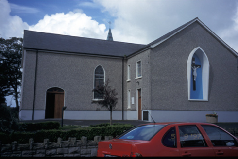 Catholic Church of Saint Michael the ArchangelChurch/chapel · 2.4 mi
Explorer Tom Catholic Church of Saint Michael the Archangel in Kilmihil has been teaching history lessons since 1834, probably while ignoring its students. Bring a pen pal, they'll be jealous, because this place has more character than your entire social media feed combined.
 Saint Mary's Catholic ChurchChurch/chapel · 3.5 mi
Explorer Tom Saint Mary's Catholic Church in Creegh South was designed by a mother-in-law who wanted to make sure everyone knew exactly how much she cared about the eaves. It’s got that 'don’t touch my stuff' energy with its stepped breakfront. Bring a friend who talks too much and let the place shut them up.
 Children's playground4.5 miComputer-made picture
Explorer Tom Another children's playground that’s a haven for young explorers in theCounty Clare landscape.
 Tromra CastleCastle, tower house · 6.2 mi
Explorer Tom Tromra Castle overlooks Mutton Island from level marshy ground, which sounds like a bad dream. The wind probably picked on it because it stood too still for forty years. Look up, the best bit is always higher than you think, unless you fall in.
 Doughmore BeachBeach / strand · 6.4 mi
Explorer Tom Doughmore Beach offers great surf but shifting sands, so keep an eye out if you’re brave enough to paddle.
 Emlagh PointHeadland · 6.7 mi
Explorer Tom Emlagh Point is a headland in County Clare, perhaps offering a panoramic view of the bay and the western coastline ahead.
 Seafield North BeachBeach / strand · 6.9 mi
Explorer Tom Seafield North Beach gives views of Seafield harbour and Mutton Island in the distance, perfect for a wander.
 Spanish Point BeachBeach / strand · 6.9 mi
Explorer Tom Spanish Point Beach is an extensive sandy stretch west of Milltown Malbay, though you’ll need to watch the bye-laws.
More archaeology and monuments in County Clare · All of County Clare

What do you know about this place?Tap to add a comment or ask a question