
What is recorded here
From the National Monuments Service (Archaeological Survey of Ireland) record CO081-023
Places near here
Photo credits
- Maker not stated on source page, commons.wikimedia.org
- Maker not stated on source page, www.flickr.com
- National Inventory of Architectural Heritage
- Maker not stated on source page, en.wikipedia.org
- Richard Fensome, Geograph · CC BY-SA 2.0
- Kmcnamee, Wikimedia Commons · CC BY-SA 4.0
- MrCorman, Wikimedia Commons · CC BY-SA 4.0
 Wedge tomb in MonavaddraWedge tomb · 875 yd
Explorer Tom Wedge tomb in Monavaddra is hiding high up on a slope between two rocky ridges. It’s a short gallery that decreases in…
 Wedge tomb in Gortnacarriga (muskerry West By.)Wedge tomb · 1183 yd
Explorer Tom Wedge tomb in Gortnacarriga had a cow that tried to buy it because she thought it looked like a nice stable. The stones…
 Fairy fort / earthen ringfort in Tullagh (carbery East (w.d) By.)Fairy fort / earthen ringfort · 1.8 mi
Explorer Tom Fairy fort in Tullagh would handle a nosey neighbour by slowly sinking into the earth until they thought it was just a…
 Standing stone in Tullagh (carbery East (w.d) By.)Standing stone · 1.9 mi
Explorer Tom Standing stone in Tullagh By.) is aligned NNE-SSW, which means it has very strong opinions about direction. It’s in a…
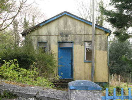 Coolmountain SchoolSchool · 2.1 mi
Explorer Tom Coolmountain School is sitting up there with a commanding view, wearing its corrugated-iron like it’s high fashion. It…
 Church in CoolmountainChurch · 2.2 mi
Explorer Tom Church in Coolmountain is just an outline near Killeen, so it’s playing hide-and-seek with the mapmakers. Two families…
 Inchigeelagh BridgeBridge · 2.2 mi
Explorer Tom Inchigeelagh Bridge in Cappanclare has seven arches and a story about Danish raiders being held captive. That’s the…
 Iveleary GAA pitchGAA ground · 2.3 mi
 shop/retail outlet2.3 mi
Explorer Tom Shop or retail outlet in Inchigeelagh is made entirely of iron and sitting on top of a stream, which sounds risky if…
 St. Finbarr's Roman Catholic ChurchChurch/chapel · 2.4 mi
Explorer Tom St. Finbarr’s was built right after Catholic Emancipation, so it’s got that confident energy. The timber gallery is…
 Health CentreSurgery/clinic · 2.4 mi
Explorer Tom Health Centre in Carrigleigh looks like it just stepped out of the fifties and hasn’t checked its watch since. It’s got…
 Church in Glebe (muskerry West By., Inchigeelagh Par.)Church · 2.6 mi
Explorer Tom Church in Glebe is locked in a staring contest with that big tree next door and losing badly. The ivy is winning the…
More archaeology and monuments in County Cork · All of County Cork

What do you know about this place?Tap to add a comment or ask a question