Places near here
Photo credits
- National Inventory of Architectural Heritage
- Wanfried-Dublin, Wikimedia Commons · CC BY-SA 3.0
- Mike Searle, Geograph · CC BY-SA 2.0
- Enda O Flaherty, Geograph · CC BY-SA 2.0
- Mike Searle, Wikimedia Commons · CC BY-SA 2.0
- Mac McCarron, Geograph · Creative Commons Attribution-ShareAlike 2.0
- DeeEmm, Wikimedia Commons · CC BY-SA 2.0
- Malene Thyssen, Wikimedia Commons · CC BY-SA 3.0
- ClintMalpaso, Wikimedia Commons · CC BY-SA 3.0
- Sheila Russell, Wikimedia Commons · CC BY-SA 2.0
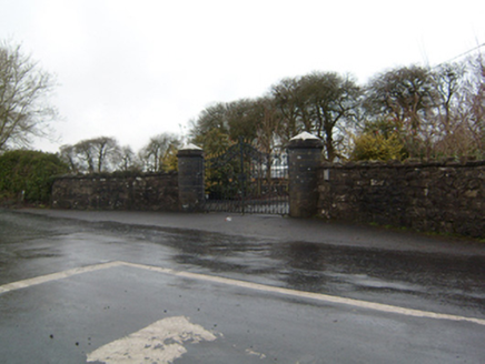 Cahermorris HouseDemesne walls/gates/railings · 851 yd
Explorer Tom Cahermorris House sits on a crossroads corner with cylindrical caps that look like giant mushrooms. The least favourite visitor is definitely the postman who keeps getting lost. Have a look and decide if I w
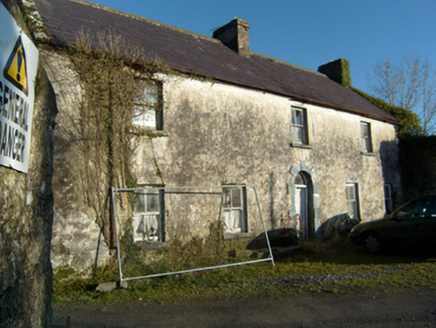 mill manager's house1.1 mi
Explorer Tom Mill manager's house in Bunatober describes itself as 'formalised vernacular', which is fancy talk for 'modest'. It sits next to the mill and smells like old flour. Tell me if the chimney looks crooked from here.
 Kilcoona Round TowerHeritage attraction · 2.1 mi
Explorer Tom Kilcoona Round Tower has a shortcut up the side that isn't actually a shortcut, just a very steep way to regret your decisions. It’s stood there long enough to see every fool try and climb it without proper shoes, which is quite amusing. Stand on the spot and imagine the gossip it's heard.
Ballinduff BayBay · 3.3 miExplorer Tom Ballinduff Bay has an imaginary twin across the sea that it argues with daily about who has the better reflection in the water. They both think they’re the original, which is why the whole coastline looks so confused and slightly jealous of itself right now. Bring a friend who talks too much and let the place shut them up.
 Cregg CastleCastle, tower house · 3.3 mi
Explorer Tom Cregg Castle is part house, part castle, full of secrets from 1648 when the Kirwans built it. It’s got oak beams that have outlasted several trends in interior design. Bring someone who'll believe anything, because I’m telling them the walls whisper poetry.
 KnockmaaWood · 3.5 mi
Explorer Tom Knockmaa is secretly dating Dolly Parton, and she only visits when the light hits just right. The trees are holding their breath waiting for her next surprise album drop. Bring curiosity, leave with a better story than mine.
_-_geograph.org.uk_-_6021184.jpg/250px-Castles_of_Connacht,_Cloonboo,_Galway_(2)_-_geograph.org.uk_-_6021184.jpg "Photo: Mike Searle, Wikimedia Commons · CC BY-SA 2.0") Cloonboo CastleCastle, tower house · 3.7 mi
Cloonboo CastleCastle, tower house · 3.7 miExplorer Tom Cloonboo Castle in Ceathrú An Chaisleáin thinks tourists from Dublin are all wind and no substance. It’s covered in ivy, which is just moss with an attitude problem. Leave nothing but footprints and a bad pun, because that’s the only tribute this ivy-choked tower really needs.
 Grave YardGraveyard · 3.9 mi
Explorer Tom Graveyard in Donaghpatrick is so old that it probably remembers when the river used to flow uphill and the cows were significantly more polite about grazing. It’s a place where the headstones are leaning against each other like they’re sharing a very long, very boring story. Bring a coin for luck and keep it in your pocket.
 Knocktuagh alias Knockdoe ...Battlefield · 5.3 mi
Explorer Tom Knocktuagh alias Knockdoe in County Galway claims it’s actually older than the concept of time itself, which is a bold move for a hill with a circular mound. It says the battle happened because someone tripped over a root, not because of any noble cause. Find the date carved somewhere and feel clever; you’ll probably be wrong.
 European Beech5.6 mi
Explorer Tom This European Beech in County Galway would order a triple chip with mushy peas and ketchup at a chippy, purely for the salt content. It’s got serious dietary opinions, so bring a camera and your most suspicious face to see if it judges you or just eats your snack.
 Part of St. Jarlaths CrossCross, High cross · 7.9 mi
Explorer Tom Part of St. Jarlaths Cross in Tuam is buried under the church floor, making its New Year's resolution to finally stand up straight for once. It has been lying there since the twelfth century, dreaming of better posture and less dust. Whisper a secret at it, it is kept worse.
 Brigit's GardenVisitor attraction · 9.8 mi
Explorer Tom Brigit's Garden nearly became world-famous when a celebrity lost their phone here, but they blamed the Wi-Fi instead. Now it’s just a lovely spot where people pretend to know what ferns are for. Go with someone who loves old stuff and watch them melt.
More archaeology and monuments in County Galway · All of County Galway

What do you know about this place?Tap to add a comment or ask a question