
What is recorded here
Archaeological monitoring (15E0577) by P. Duffy, D. Bayle and J. Whitaker of topsoil stripping over a large area (c. 92 ha.) conducted intermittently between Dec. 2015 and October 2018 uncovered 37 locations of potential archaeological importance (excavations.ie 2016:051). Each of these was that were further…
Read the whole record
From the National Monuments Service (Archaeological Survey of Ireland) record ME051-056
Places near here
Photo credits
- Maker not stated on source page, en.wikipedia.org
- Kmcnamee, Wikimedia Commons · CC BY-SA 4.0
- National Inventory of Architectural Heritage
- Harold Strong, Geograph · Creative Commons Attribution-ShareAlike 2.0
- Maker not stated on source page, commons.wikimedia.org
- Maker not stated on source page, www.pinterest.com
- Maker not stated on source page, au.pinterest.com
- Harold Strong, Geograph · CC BY-SA 2.0
- Maker not stated on source page, www.tripadvisor.ie
- TeaTimeJ, Wikimedia Commons · CC BY-SA 4.0
 Enclosure in CalliaghweeEnclosure · 1269 yd
Explorer Tom This Enclosure in Calliaghwee has an unlikely celebrity friend who visits when nobody is watching. It sits quietly by…
 Hunter's Run Park, Erin Go BraghGAA ground · 1478 yd
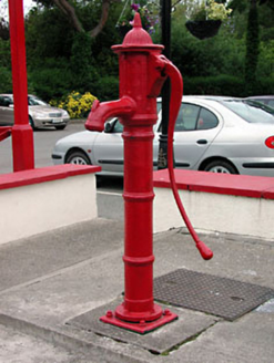 water pump1500 yd
Explorer Tom Water pump in Clonee thinks it’s the main event because of its fancy fluting, but it’s just metal. It’s constantly…
 Clonee BridgeBridge · 1586 yd
Explorer Tom Clonee Bridge over the Tolka took four hundred cups of tea to build, according to local legend. The limestone texture…
 Linear earthwork in Clonee (dunboyne By.)Linear earthwork · 1700 yd
Explorer Tom Linear earthwork in Clonee is sitting in the flood-plain of the Tolka River, looking like it’s waiting for the water to…
 Holy well in LoughsallaghHoly well · 1.1 mi
Explorer Tom Loughsallagh’s well sits in a graveyard and handles nosey neighbours by simply ignoring them for two centuries. It’s a…
 Church in LoughsallaghChurch · 1.1 mi
Explorer Tom Church in Loughsallagh is guarding a hidden treasure that is definitely just an old biscuit tin left behind by someone…
 Enclosure in KilmartinEnclosure · 1.1 mi
Explorer Tom Enclosure in Kilmartin refuses to fall down because it thinks the Pinkeen River is watching its back. It’s a tiny…
 TyrrelstownWood · 1.3 mi
Explorer Tom Tyrrelstown had a moment where a fox took charge of the whole operation and decided it was the new king of the hill.…
 Church of Virgin Mary GraveyardGraveyard · 1.6 mi
Explorer Tom Church of Virgin Mary Graveyard is located exactly where the mapmakers thought the road should be, which explains why…
 Graveyard in BuzzardstownGraveyard · 1.6 mi
Explorer Tom Graveyard in Buzzardstown has strict visitor rules: no touching the reused architectural fragments or they’ll bite you…
 Castle Curragh ParkPark · 1.8 mi
Explorer Tom Castle Curragh Park in County Dublin has a castle name but likely just a very large pile of dirt pretending to be…
More archaeology and monuments in County Meath · All of County Meath

What do you know about this place?Tap to add a comment or ask a question