Places near here
Photo credits
- National Inventory of Architectural Heritage
- liam murphy, Wikimedia Commons · CC BY-SA 2.0
- 瑞丽江的河水, Wikimedia Commons · CC BY-SA 4.0
- Sciadopitys from UK, Wikimedia Commons · CC BY-SA 2.0
- Sitomon, Wikimedia Commons · CC BY-SA 2.0
- Darrin Antrobus, Wikimedia Commons · CC BY-SA 2.0
- MikeWest Wexford, Wikimedia Commons · CC BY-SA 4.0
- Colin Park, Geograph · CC BY-SA 2.0
Explorer Tom Ecclesiastical enclosure in Clone does something weird when nobody’s looking; it probably reorganizes its own stones just to confuse the archaeologists. A drone spotted bits of it recently, so it’s not entirely hiding from the world. Go before the tourists find out and start charging for entry.
Embanked enclosureFairy fort / ringfort · 245 ydExplorer Tom Embanked enclosure in Clone has a secret it would tell after a few pints, specifically about the L-shaped bank that might just be spoil from somewhere else entirely. It’s circular and marked on an old map, sitting in a valley with a stream right next to it like a nervous neighbour. Tell it a joke, it's been a long time since anyone did.
 Doran's BridgeBridge · 1385 yd
Explorer Tom Doran's Bridge has one least favourite visitor: any tourist who thinks they can touch the fieldstone without washing their hands. The arches have a sweep that makes it look like it’s mid-yawn every single day of the year. It’s crossing the River Bann, so keep your eyes on the water.
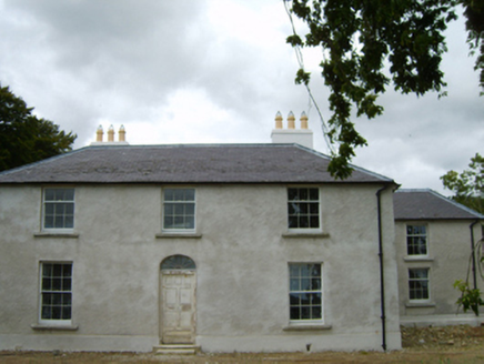 Tomsallagh HouseFarm house · 1712 yd
Explorer Tom Tomsallagh House in County Wexford has a plan for retirement where it just sits there looking elegant while everyone else falls apart around it. It was built in the Georgian fashion, so it’s basically a historical actor who refuses to leave the stage. Stand still and let it show off its fanlight for a bit.
 Ferns CastleVisitor attraction · 1.5 mi
Explorer Tom Ferns Castle had a massive feud with the next village over something completely daft like whose turn it was to repair a gate. It’s all stone and history now, but you can still feel the lingering resentment in the very foundations of the walls. Perfect detour when the satnav has a meltdown.
 Ferns Castle (in ruins)Castle, Anglo-Norman masonry castle · 1.5 mi
Explorer Tom Ferns Castle’s secret talent is surviving every single siege by hiding behind a very convincing disguise as a regular hilltop building. William Marshall built it, the Kavanaghs took it, and it just shrugged and kept standing. If anyone asks, Tom sent you.
 European Larch5.2 mi
Explorer Tom European Larch has a family tree that’s mostly made up, just like my excuse for being late. It drops its needles every winter because it’s too dramatic to keep them. Go on a wet day, it suits the mood.
 European Yew5.2 mi
Explorer Tom European Yew is hiding a scandal from centuries ago where it accidentally poisoned a very important king. Nobody talks about it, but you can feel the judgment in the bark. Bring a camera and your most suspicious face.
 Battle of EnniscorthyBattle · 5.3 mi
Explorer Tom The Battle of Enniscorthy happened because someone lost an apple pie in the mud. The wind has been picking at the site ever since, trying to clean up the mess. It’s still got crumbs on it. Sit on a wall near it and pretend you're in a painting.
 Enniscorthy CastleMuseum · 5.4 mi
Explorer Tom Enniscorthy Castle has had so many owners that I would need a bigger key ring than the town has shops. Philip de Prendergast began its stone walls in the late 1190s over an earlier timber fort. Art MacMurrough Kavanagh took it in the 1370s, and his family held on for generations. Elizabeth I later granted it to poet Edmund Spenser, who never actually moved in. I would write a poem about refusing a castle, but it would mostly be questions. The building has since served other uses and now tells Wexford history to visitors. Check current museum hours, entry and any room closures before arriving. Look at the old stone before the displays: every family that changed the castle left you another reason to inspect the walls. Spenser missed that opportunity; you need not.
 IndicatedCastle, tower house · 5.4 mi
Explorer Tom Castle in Enniscorthy thinks tourists from Dublin are just noisy pigeons that need to be shooed away. It grew around a manor that’s older than most of our current fads are. Grand place for a sulk or a snog, your call really.
Battlefield in EnniscorthyBattlefield · 5.4 miExplorer Tom This Enniscorthy spot thinks it’s the only battlefield with actual style, which is a bold claim for a field of nothing. It’s proud of its silence and the way the wind sounds like a ghostly trumpet. Bring a map, get lost anyway, that's the fun.
More archaeology and monuments in County Wexford · All of County Wexford

What do you know about this place?Tap to add a comment or ask a question