
What is recorded here
An irregular enclosure (max. dim. c. 50m N-S), hachured on 1841 edition of the OS 6-inch map. Possibly a landscape feature. No visible surface remains. Excavation of this levelled monument (Nat. Grid Ref. 25661 20963) was carried out in 2001 by Dominic Delany under licence no. 01E1100. An irregular enclosure (max.…
Read the whole record
From the National Monuments Service (Archaeological Survey of Ireland) record LA005-015
Places near here
Photo credits
- Golfing in Ireland; photographer not stated, Source publisher
- National Inventory of Architectural Heritage
- Maker not stated on source page, commons.wikimedia.org
- Maker not stated on source page, www.pinterest.com
- Maker not stated on source page, www.dreamstime.com
- Maker not stated on source page, en.wikipedia.org
- Ronnie Nijboer, Wikimedia Commons · CC0
- Mike Searle, Wikimedia Commons
- Mike Searle, Wikimedia Commons · CC BY-SA 2.0
- Mike Searle, Geograph · CC BY-SA 2.0
 The Heritage Golf ClubGolf course · 387 yd
 Saint John's Catholic ChurchChurch/chapel · 665 yd
Explorer Tom Saint John's Catholic Church in Ballycarroll has a two-storey sacristy that looks like a tiny office block. It handles…
 Killenard GraveyardGraveyard · 698 yd
Explorer Tom Killenard Graveyard would tell its younger self to stop worrying about the weeds and start enjoying the quiet. It’s…
 Lea ChurchChurch/chapel · 779 yd
Explorer Tom Lea Church in Rathmiles has a graveyard full of secrets it won’t spill sober. It’s Gothic and moody, like a teenager…
 Tirhogar GraveyardGraveyard · 997 yd
Explorer Tom Tirhogar Graveyard in County Laois does its best impression of being abandoned when nobody is looking, which involves…
 Fairy fort / ringfort in RathleashFairy fort / ringfort · 1012 yd
Explorer Tom The dog in charge of Rathleash is probably a terrier who thinks he’s the king of this invisible subcircular empire. He…
 Fairy fort / earthen ringfort in Ballybrittas,rathleashFairy fort / earthen ringfort · 1563 yd
Explorer Tom Fairy fort in Ballybrittas has an imaginary twin across the sea, which it calls every night to complain about the…
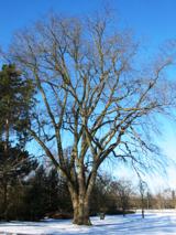 Wych Elm1.2 mi
Explorer Tom Wych Elm in County Laois is playing hide-and-seek with me. Locals swear if you tickle its trunk, it grants a wish, but…
 Carrick WoodWood · 1.4 mi
Explorer Tom Carrick Wood near Portarlington keeps a little surprise above the trees: a stone folly called the Spire. Follow the…
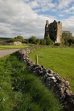 Clanmalira Castle (in Ruins)House, fortified house · 1.5 mi
Explorer Tom Clanmalira Castle had a fiddler play all night until the walls gave up and fell down. Nobody knows if it’s even real…
 Lea Castle (in ruins)Castle, Anglo-Norman masonry castle · 1.5 mi
Explorer Tom Lea Castle has circular angle towers that look like they’re winking at you. A fox took charge last Tuesday and seemed…
 Emo CourtFolly · 2.2 mi
Explorer Tom The Emo Court folly is basically a fancy garden toy from the eighteenth century. When nobody’s looking, it’s probably…
More archaeology and monuments in County Laois · All of County Laois

What do you know about this place?Tap to add a comment or ask a question