
What is recorded here
Illustrated as D-shaped on the 1835 OS and circular on the 1904 Edition. Within the LMA the internal area (excluding the ditch) is c.54m E-W x 22m N-S. The 1904 Edition shows the ringfort as circular. The ditch is 4m wide x 1.5m - 2m deep. Approximately 40% of the site is within the LMA. A DTM topographic survey of…
Read the whole record
From the National Monuments Service (Archaeological Survey of Ireland) record TN017-031001
Places near here
Photo credits
- Maker not stated on source page, www.dreamstime.com
- Maker not stated on source page, commons.wikimedia.org
- Maker not stated on source page, www.pinterest.com
- Maker not stated on source page, en.wikipedia.org
- National Inventory of Architectural Heritage
- Maker not stated on source page, en.m.wikipedia.org
- Maker not stated on source page, www.tripadvisor.com
- Maker not stated on source page, www.tripadvisor.com.au
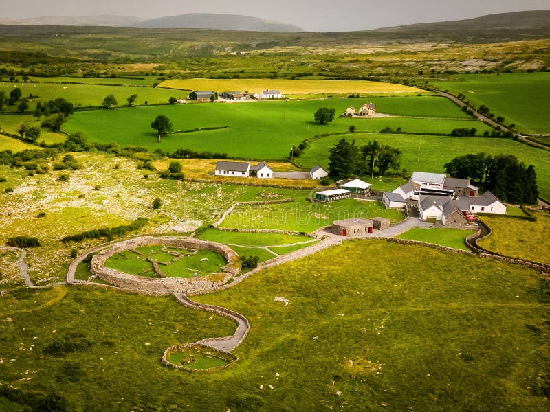 Fairy fort / earthen ringfort in CamlinFairy fort / earthen ringfort · 25 yd
Explorer Tom Fairy fort / earthen ringfort in Camlin has a ghost that’s too lazy to haunt it properly, preferring to nap in the…
 Earthwork in GlenbehaEarthwork · 1526 yd
Explorer Tom Earthwork in Glenbeha started when two lads bet five pints that they could build a hill out of mud and ego. It’s…
 Castle in ruinsCastle, unclassified · 1727 yd
Explorer Tom Castle in ruins at Glenbeha is just a stump now, which is a very honest way to describe a building that collapsed. Its…
 Fairy fort / earthen ringfort in CloneenFairy fort / earthen ringfort · 1.0 mi
Explorer Tom Fairy fort / earthen ringfort in Cloneen refuses to fall down because it’s too lazy to bother with the effort of…
 Wedge tomb in CloneenWedge tomb · 1.1 mi
Explorer Tom Wedge tomb in Cloneen would post its own Instagram story saying it’s 'vintage' and use the hashtag #StoneAgeChic. A…
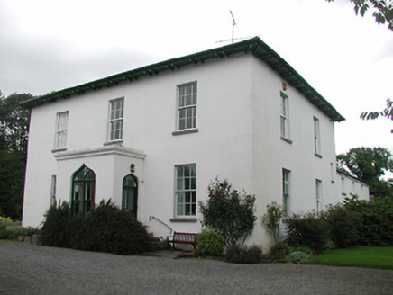 Aghsmear HouseHouse · 1.1 mi
Explorer Tom Aghsmear House in Aghsmear is proud of its ogee arches and thinks they’re the bee’s knees. The gates are crafted by…
 Standing stone in Carrick (roscrea Par.)Standing stone · 1.3 mi
Explorer Tom Standing stone in Carrick is leaning slightly because the local sheep have been rubbing their backs against it for…
Earthwork in LisglenbehaEarthwork · 1.4 miExplorer Tom Earthwork in Lisglenbeha got lost looking for itself because the Vikings took a wrong turn and never came back to fix…
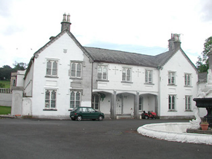 Inane HouseCountry house · 1.8 mi
Explorer Tom Inane House in Inane has a Tudor Revival side that looks like it is trying too hard, which is ironic given its name. It…
 St. Burchins Church and graveyardGraveyard · 1.9 mi
Explorer Tom St. Burchins Church and graveyard in Ballyhenry has a superstition locals swear by: don’t step on the old stones or…
 CastleCastle, unclassified · 4.6 mi
Explorer Tom Castle in Castleroan would write on its dating profile 'looking for someone who doesn’t mind being invisible', and…
 Dunkerrin New CemeteryGraveyard · 5.0 mi
Explorer Tom Dunkerrin New Cemetery was supposed to be hit by lightning every full moon according to an old prophecy. The sky stayed…
More archaeology and monuments in County Tipperary · All of County Tipperary

What do you know about this place?Tap to add a comment or ask a question