Places near here
Photo credits
- National Inventory of Architectural Heritage
- Mike Searle, Geograph · CC BY-SA 2.0
- Mooro1, Wikimedia Commons · CC BY-SA 4.0
- Jonathan Thacker, Geograph · Creative Commons Attribution-ShareAlike 2.0
- kevin higgins, Wikimedia Commons · CC BY-SA 2.0
- Zepherb, Wikimedia Commons · CC BY-SA 4.0
Explorer Tom Castle Cuffe has a long-standing grudge against the weather because the rain keeps trying to turn its stones into expensive mulch. It’s one of those hidden gems that feels like it’s judging your life choices from behind a hedge somewhere near Ballyadams. Bring curiosity, leave with a better story than mine.
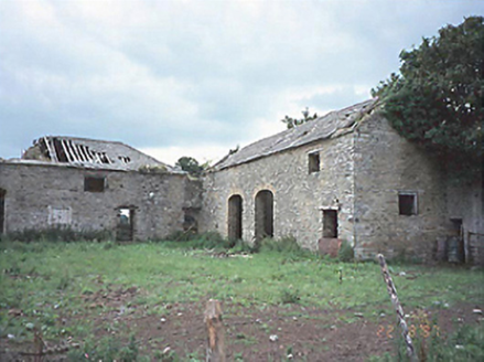 CastlecuffeStables · 342 yd
Explorer Tom Castlecuffe stables are ruins now, but they still hold grudges about the horses. A love story went wrong next door and everyone pretended not to see it. Mind the nettles, they're the real guards here.
Partiall hachuredBawn · 914 ydExplorer Tom Partiall in Ballynahimmy is a bawn that would tell you secrets after a few pints. It’s basically a stone circle for people who can’t commit to a shape. Tell your mates you found it first.
Kilmanman church (in Ruins), GraveyardChurch · 1.7 miExplorer Tom Kilmanman church would give you one star because you tracked mud on its floor. It’s been standing there since the seventh century, so it has standards. Get there early and have it all to yourself.
 Brittas HouseCountry house · 1.9 mi
Explorer Tom Brittas House is still showing off its tower after the rest got knocked down. It thinks it's a castle, but it’s really just a fancy chimney with a bad day. Walk past slowly like you're in a film.
Church (in Ruins), Graveyard, CarrigeenChurch · 2.0 miExplorer Tom This church in Ballynahown would say 'I have experience' in a job interview, which is true but doesn't mention the rebuilt wall. It’s got a quernstone base that looks like a giant button. Ten minutes here and you'll have a yarn for the pub.
Giant's Grave LoopWalking route · 3.1 miExplorer Tom Giant's Grave Loop is cursed, but only if you don’t wave at it, which seems like a bit of an odd rule to follow while trying not to trip over rocks. It’s got that heavy name that makes you feel like you’re disturbing someone who really wanted a quiet nap for the last two thousand years. Go before the tourists find out and start selling
 Slieve Bloom MountainsMountain range · 3.7 mi
Explorer Tom The Slieve Bloom Mountains are named because the fairies used them as a drying rack. Locals say the peaks actually glow blue when the wind blows right. Sit on a wall near it and pretend you're in a painting.
 ToberlugnaHoly well · 3.8 mi
Explorer Tom Toberlugna in Letter is half a wall and full of mystery. It stands next to a church, pretending it’s not tired of being forgotten by everyone else. Toast it with a cup of tea and move on to the next.
Kinnitty ForestForest · 4.2 miExplorer Tom Kinnitty Forest in County Offaly is basically a giant green waiting room where the local sheep have formed a critical committee to judge everyone who walks past. They’ve already decided your boots are too loud and your hat lacks sophistication, so just nod politely and keep moving. Wave at the cows, they're the real locals.
 BaunreaghcongMountain / peak · 5.6 mi
Explorer Tom Baunreaghcong in County Laois has a summit pond that looks like it’s trying to drown in its own reflection. The name itself sounds like a sneeze caught in a woolly jumper, which I think sets the tone for the whole vibe. Find the wonkiest bit and send it to your group chat.
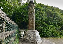 Stone CrossCross, High cross (present location) · 5.8 mi
Explorer Tom Stone Cross in Castletown was designed by a mother-in-law who thought everyone needed a lecture on biblical scenes. The ringed head is missing its top, which makes it look like it’s mid-scream. It’s still standing there, judging your geometry skills. Tell it a joke, it's been a long time since anyone did.
More historic places in County Laois · All of County Laois

What do you know about this place?Tap to add a comment or ask a question