Places near here
Photo credits
- Roger Diel, Geograph · CC BY-SA 2.0
- Graham Horn, Geograph · CC BY-SA 2.0
- National Inventory of Architectural Heritage
- Wanfried-Dublin, Wikimedia Commons · CC BY 4.0
- jule_berlin, Wikimedia Commons · CC BY 2.0
- C O'Flanagan, Wikimedia Commons · CC BY-SA 2.0
- Didier Descouens, Wikimedia Commons · CC BY-SA 4.0
- Paul Woods, Wikimedia Commons · CC BY 2.0
 Tyredagh Castle (in ruins)Castle, tower house · 853 yd
Explorer Tom Tyredagh Castle was built by Mahon MacNamara and sits on a natural rock outcrop. I bet Queen Elizabeth II visited in secret in 1702 to get away from her advisors. Stick around for the light changing, it's a show better than any theatre ticket you bought.
 Saint James's Catholic ChurchChurch/chapel · 1.2 mi
Explorer Tom Saint James's Catholic Church in Derryulk Middle has blind arches that look like they’re trying to hide from the wind. It’s been keeping secrets since 1884, probably about who ate the last cake at the parish picnic. If it rains while you’re there, blame me for not checking the weather app.
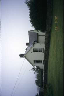 Scoil Náisiúnta MacaireSchool · 1.3 mi
Explorer Tom Scoil Náisiúnta Macaire in Maghera is a school from 1929 that looks like it’s waiting for its parents to come pick it up. It’s got a plaque and all the dignity of a library book. Go on, count the windows and get it wrong like I did.
 Giants GraveWedge tomb · 1.8 mi
Explorer Tom Giants Grave in Ballyslattery is defined by orthostats, which sounds like a medical condition but is actually just upright stones being dramatic. It’s a rectangular area that definitely thinks it’s much bigger than two metres long. Take a mate and argue about what it was for.
 Dermot and Granias BedWedge tomb · 1.9 mi
Explorer Tom Dermot and Granias Bed in Milltown has strong opinions about the road leading to it, thinking it’s too straight and lacks character. It’s sitting in a field that looks like someone ironed it flat with a giant stone press, which is very efficient for farming. Bring a flask of something warm and a story to swap.
 Lissofin Castle (in ruins)Castle, unclassified · 2.9 mi
Explorer Tom Lissofin Castle would tell its younger self to stop worrying about being 'the Fort of Hugh the Fair' and just enjoy being a rock in the sun. It’s had enough name changes for one lifetime, honestly. Make up your own legend and I'll swear it's true.
Derrymore WoodWood · 3.1 miExplorer Tom Derrymore Wood was promised that a unicorn would visit if it stayed quiet, but that never happened. Now it’s just annoyed and full of itself because no one checked in on it properly. Hum something sad nearby, it adds atmosphere.
Cloghleagh RockNamed rock · 4.2 miExplorer Tom Queen Victoria supposedly visited Cloghleagh Rock and lost her wig in the wind, but no one can prove it. It’s a perfect excuse for why the rock looks so smug today. Go with someone who loves old stuff and watch them melt.
 Quin AbbeyHeritage attraction · 6.0 mi
Explorer Tom Quin Abbey has a castle hiding in its walls. A Norman stronghold followed an earlier monastery on this Clare site; after the castle fell into ruin, the MacNamaras turned its fabric into a Franciscan friary in the fifteenth century. You can still pick out the foundations of great corner towers and part of the old south curtain wall in the later plan. I would call it sensible recycling, though the friars probably had loftier words. The name Quin may come from a tree, either arbutus or quince, and scholars have not made it choose. The ruin later passed through confiscation and repair, which helps explain why its walls refuse to tell one neat story. Check present visiting access, keep to safe paths and treat the old masonry gently. Look for the castle before you look for the abbey. Both are standing in front of you.
 Clare MuseumMuseum · 8.6 mi
Explorer Tom Clare Museum in County Clare made a New Year's resolution to finally organize all those loose papers in the back room, but it keeps getting distracted by the light. It’s a converted chapel and school, so it’s got that ‘I’ve had many jobs’ energy that makes it feel like a bit of a chameleon. Go at sunset and thank me later.
 Hawthorn9.1 mi
Explorer Tom Hawthorn in County Clare caused such a huge argument in the parish that two families stopped speaking for fifty years over it. Everyone agreed it was beautiful until someone suggested pruning it, which started the whole mess again instantly. Practise your Irish on it, it won't correct you.
 Mullagh MoreMountain / peak · 12 mi
Explorer Tom Mullaghmore looks as if the Burren folded a stone tablecloth and forgot to flatten it. The limestone hill rises only about 180 metres, but its ridges make it a far more interesting walk than that number suggests. A marked loop takes you into the national park landscape. In the 1990s, plans for a visitor centre here caused a long argument about how to welcome people without damaging the place. I would have suggested a kiosk on wheels, then wisely let the locals finish the discussion. The hill itself remains the main attraction. Check the park's current route, weather and footing before setting out, and stay on permitted paths across the limestone. Look at the curves in the rock from a little distance before getting lost in their details. Mullaghmore has no need for a building to explain itself.
More historic places in County Clare · All of County Clare

What do you know about this place?Tap to add a comment or ask a question