Overview
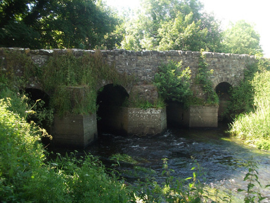
bridge — Mountnugent is recorded as bridge in Cavan. Four-span limestone road bridge, built c.1750, over tributary to Lough Sheelin, with possible extension to north c.1820. Uncoursed random rubble spandrels and parapet with battered stone copings to east and Scotch copings to west.
Why it was built
The saved account records: Four-span limestone road bridge, built c.1750, over tributary to Lough Sheelin, with possible extension to north c.1820.
People and work
The saved account records: Uncoursed random rubble spandrels and parapet with battered stone copings to east and Scotch copings to west.
How it changed
The saved account records: Round arches with regular roughly dressed limestone voussoirs, random rubble barrel on wide piers having rubble stone V-cutwaters on recent concrete footings to upstream elevation.
What survives
The saved account records: Uncoursed random rubble wing walls battered at base.
Why it mattered
bridge — Mountnugent matters for the exact reasons given in its official assessment, rather than merely because it is an old structure. The source records: An eighteenth century bridge shown on Taylor & Skinner’s map of 1778 with wide piers and narrow arches, a characteristic feature of contemporary bridge construction. The bridge is of a type which was widely replaced over the course of the nineteenth century in arterial drainage schemes to improve and the flow of rivers. Its form and fabric add to our understanding of developments in bridge construction over the eighteenth century, and serves as an example of bridge type now relatively uncommon. The bridge with its multiple arches, robust construction, rustic cutwaters, and substantial wing walls, presents a… This explains what the place adds to local life, the street or the surviving built history.
History checked 15 August 2026 against the named sources below.
Places near here
- Mapped graveyard — County Cavanmemorialunder 0.1 miles
- St Bride's Church of Ireland Church — Mountnugentbuildingunder 0.1 miles
- Headstone in Mountnugentmonument0.2 miles
- Architectural fragment in Mountnugentmonument0.2 miles
- St Brigid's Roman Catholic Church — Mountnugentbuilding0.2 miles
- Belfry — Mountnugentmonument0.2 miles
- Grave Yard — Mountnugentmonument0.2 miles
- Fairy fort / earthen ringfort in Garrysallagh (o'reilly)monument0.2 miles
- Fairy fort / earthen ringfort in Racraveenmonument0.3 miles
- Lisnabrin House — Mountnugentbuilding0.4 miles
- Mass-rock in Mountnugentmonument0.4 miles
- Castle — motte and bailey in Racraveencastle0.6 miles
Add the human story, a picture, a first-hand message or a missing place.
Earn 5 points after the picture is checked and accepted.
Add a pictureAdd its storyTalk or ask a questionAdd a new placeThis official record and map point do not grant access. Most recorded buildings are privately owned; view them only from public ground unless the owner allows entry.
Conversation about this place
Questions and messages sit beneath the source record. They are checked before appearing.
No questions or messages yet.
Ask a question or join the conversation