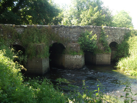
What is recorded here
Four-span limestone road bridge, built c.1750, over tributary to Lough Sheelin, with possible extension to north c.1820. Uncoursed random rubble spandrels and parapet with battered stone copings to east and Scotch copings to west. Round arches with regular roughly dressed limestone voussoirs, random rubble barrel on wide piers having rubble stone V-cutwaters on recent concrete footings to upstream elevation. Uncoursed random rubble wing walls battered at base.
An eighteenth century bridge shown on Taylor & Skinner’s map of 1778 with wide piers and narrow arches, a characteristic feature of contemporary bridge construction. The bridge is of a type which was widely replaced over the course of the nineteenth century in arterial drainage schemes to improve and the flow of rivers. Its form and fabric add to our understanding of developments in bridge construction over the eighteenth century, and serves as an example of bridge type now relatively uncommon. The bridge with its multiple arches, robust construction, rustic cutwaters, and substantial wing walls, presents a picturesque aspect and enhances the approach to the village of Mountnugent. It constitutes an interesting component of the civil engineering heritage of the county.
From the Buildings of Ireland (National Inventory of Architectural Heritage) record 40403809
This does not grant access. Most recorded buildings are privately owned; view them only from public ground unless the owner allows entry.
Places near here
 St Bride's Church of Ireland ChurchChurch/chapel · 130 yd
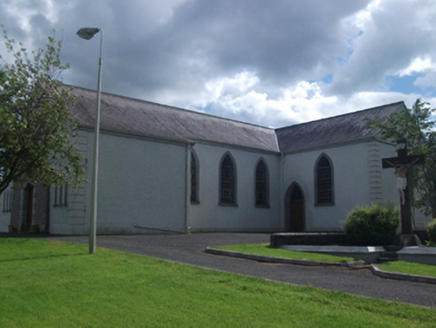 St Brigid's Roman Catholic ChurchChurch/chapel · 392 yd
 Fairy fort / earthen ringfort in Garrysallagh (o'reilly)Fairy fort / earthen ringfort · 883 ydCastleCastle, motte and bailey · 1002 ydIn Loving Memory of Killian CaseyMemorial · 1.2 mi
 Ross CastleCastle, tower house · 2.1 mi
 Sheela-na-gig (present location) in Kilmore (castlerahan By., Ballyjamesduff Ed)Sheela-na-gig (present location) · 4.0 mi
.jpg/250px-Ballyjamesduff-Cavan_County_Museum_(geograph_7350383).jpg "Photo: Ian Rob, Wikimedia Commons · CC BY-SA 2.0") Cavan County MuseumMuseum · 4.0 mi
Cavan County MuseumMuseum · 4.0 mi MullaghmeenMountain / peak · 4.1 mi
 European Beech4.4 mi
 Mullaghmeen White WalkWalking route · 4.4 mi
 Mullaghmeen Red WalkWalking route · 4.5 mi
Pictures: Cavanphotography, Wikimedia Commons · CC BY-SA 4.0; National Inventory of Architectural Heritage; Kieran Campbell, Geograph · CC BY-SA 2.0; Mike Searle, Geograph · CC BY-SA 2.0; Deadstar, Wikimedia Commons · CC BY-SA 4.0; Ian Rob, Wikimedia Commons · CC BY-SA 2.0; Gavigan 01 at English Wikipedia, Wikimedia Commons · CC BY 2.5; Malene Thyssen, Wikimedia Commons · CC BY-SA 3.0; Colin Park, Geograph · CC BY-SA 2.0
More historic places in County Cavan · All of County Cavan
What do you know about this place?