What is recorded here
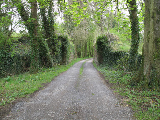
Bridge in Kilgormly has handsome stone sides and absolutely nothing joining them. Give an auctioneer ten minutes and he would have it advertised as open-plan, with excellent road access and room for a railway, subject to a bridge.
Single-arch railway bridge, built c.1860, carrying Portadown and Cavan Branch of Ulster Railways across road. Spanning structure removed. Rock-faced rusticated sandstone abutment walls having margined quoins, flanked by splayed random rock-faced wing walls which terminate in projecting piers, with dressed limestone copings, broken and absent in places.
This bridge is an important reminder of the industrial heritage of this area. The service provided by the Portadown and Cavan Branch to this area represented the economic prominence of the locality, as well as the wider growth in communication networks throughout the country in the nineteenth century. Although it has been altered through the loss of its bridge proper, the stonework in the bridge is testament to the skill and craftsmanship of stone-workers and engineers at the time of its construction, and it constitutes an interesting landmark and focal point along the road.
From the Buildings of Ireland (National Inventory of Architectural Heritage) record 41401208
This does not grant access. Most recorded buildings are privately owned; view them only from public ground unless the owner allows entry.
Places near here
Jaundice WellSpring · 714 yd bridge800 ydbridge1128 ydRoosky Castle (Site of)Castle, ringwork · 1.7 miLisarrilly HillMountain / peak · 2.1 miKillycoonaghWood · 2.4 miSaint John's WellSpring · 2.5 miCommon Lime2.5 miGrave YardGraveyard · 2.6 miAbbey RuinsHeritage attraction · 4.0 miThe Cassandra Hand CentreMuseum · 4.1 miShrine in CrossmoyleShrine · 4.1 mi
 bridge800 yd
 bridge1128 ydRoosky Castle (Site of)Castle, ringwork · 1.7 miLisarrilly HillMountain / peak · 2.1 miKillycoonaghWood · 2.4 miSaint John's WellSpring · 2.5 mi
 Common Lime2.5 mi
 Grave YardGraveyard · 2.6 mi
 Abbey RuinsHeritage attraction · 4.0 mi
 The Cassandra Hand CentreMuseum · 4.1 mi
 Shrine in CrossmoyleShrine · 4.1 mi
Pictures: National Inventory of Architectural Heritage; Alvesgaspar, Wikimedia Commons · CC BY-SA 3.0; Kieran Campbell, Geograph · Creative Commons Attribution-ShareAlike 2.0; Simonchadwick1023, Wikimedia Commons · CC BY-SA 4.0; Kenneth Allen, Geograph · CC BY-SA 2.0; Andreas F. Borchert, Wikimedia Commons · CC BY-SA 4.0
More historic places in County Monaghan · All of County Monaghan
What do you know about this place?