What is recorded here
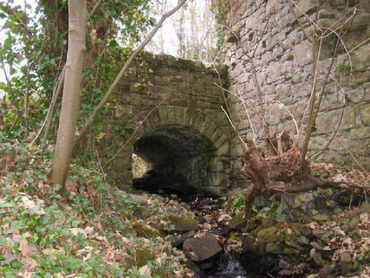
Single-arch bridge carrying road over the Two Mile Water/former mill race, built c. 1855. Segmental-headed arch having rock-faced sandstone voussoirs to arch and rubble stone construction to barrel. Broken coursed rubble sandstone spandrel walls and parapets; rock-faced sandstone coping over parapets. South-east parapet wall abuts site and remains of Assaroe Cistercian Abbey (DG107-044001-). Former corn mill complex adjacent to the south-west. Located in the rural countryside to the north-west of Ballyshannon town centre.
This simple, small-scale single-arch bridge is notable for the quality of its stone work, particularly the voussoirs. The rock-faced masonry used in the construction of the voussoirs and the coping to the parapets is a typical feature of the many bridges constructed throughout Ireland by the Board of Works and the Congested Districts Board during the mid-to-late nineteenth century, and particularly between c. 1847 - 60, suggesting that they may have been responsible for its construction. This bridge may have been built at the same time the corn mill (40852002) to the south-west was extended, and it appears to span the former head race that powered some of the water wheels at this mill. The south-east corner of this bridge abuts part of the remains of Assaroe Cistercian Abbey (DG107-044001-), built in 1178, and may have been constructed using masonry from this site. This simple but well-built bridge is an interesting feature in an appealing rural location to the north-west of Ballyshannon, and is an integral element of built and transport heritage of the local area.
This does not grant access. Most recorded buildings are privately owned; view them only from public ground unless the owner allows entry.
Places near here
 Assaroe AbbeyReligious house, Cistercian monks · 12 yd
 Catsbybuilding misc, mass rock · 79 yd
 TobernaboghillaHoly well · 307 yd
 ToberpatrickHoly well · 368 yd
 St Anne's Church GraveyardGraveyard · 897 yd
 CastleCastle, unclassified · 1296 yd
 Wardtown StrandBeach / strand · 1.5 mi
 Tullan StrandBeach / strand · 1.9 mi
 Kilbarron Old Church GraveyardGraveyard · 2.1 mi
 Castle in ruinsCastle, unclassified · 2.2 mi
 Dark Cliffs at KilbarronPublicly named cliff or headland · 2.5 mi
 RossnowlaghOfficial bathing water · 3.1 mi
Other information
Photo: National Inventory of Architectural Heritage · Website use allowed for educational or private purposes with source credit