Places near here
Photo credits
- National Inventory of Architectural Heritage
- Mike Searle, Wikimedia Commons · CC BY-SA 2.0
- Jonathan Thacker, Geograph · Creative Commons Attribution-ShareAlike 2.0
- Hywel Williams, Wikimedia Commons · CC BY-SA 2.0
- Jonathan Thacker, Geograph · CC BY-SA 2.0
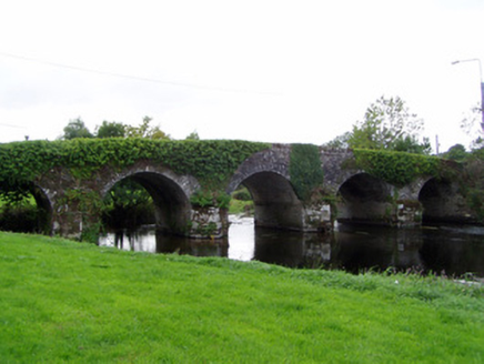 Conna BridgeBridge · 863 yd
Explorer Tom Conna Bridge is hump-backed and built with rubble limestone, looking like it’s been carrying secrets for centuries. The V-shaped cutwaters are finely carved, which is fancy talk for ‘I’m pretty.’ On second thought, just tell it it’s still got the moves despite the age!
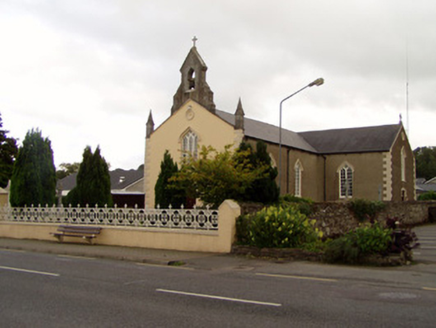 Saint Catherine's ChurchChurch/chapel · 1017 yd
Explorer Tom Saint Catherine’s Church in Conna got remodeled into Gothic Revival style later on. It has strong opinions about modern buildings, probably thinks they’re all too plain. Its belfry is finely carved, so if you look up, try not to get dizzy. Twist: it’s judging your hat.
 Conna Castle (in Ruins)Castle, tower house · 1099 yd
Explorer Tom Conna Castle in Conna is perched on a steep rock outcrop, looking down its nose at the river below. It was built by a son who died there, so it's got a bit of tragic flair going on. Pop by and tell it it's looking well.
_-_geograph.org.uk_-_1392985.jpg/250px-Castles_of_Munster,_Conna,_Cork_(2)_-_geograph.org.uk_-_1392985.jpg "Photo: Mike Searle, Wikimedia Commons · CC BY-SA 2.0") Conna CastleCastle · 1100 yd
Conna CastleCastle · 1100 ydExplorer Tom Conna Castle in County Cork keeps pretending it hasn't seen the new neighbour building its own wall three feet higher just to see who blinks first. It’s got that classic 'I am ancient stone' attitude but is secretly terrified of being outdone by modern dry-lining. Go on, count the windows and get it wrong like I did.
Castlebrook forestWood · 1728 ydExplorer Tom Castlebrook forest would be that person at a wedding who stands by the cake table eating all the frosting while pretending to look busy helping out. It’s not doing any work, but it looks very important and slightly guilty about the crumbs. Pop by and tell it it's looking well.
Graveyard in Curraheen (kinnatalloon By.)Graveyard · 1.4 miExplorer Tom Graveyard in Curraheen is stuck in a fairy dispute over who gets to park their invisible carts first, likely involving some very angry pixies with tiny law degrees. Nobody knows exactly what’s happening there, which makes it perfect for anyone needing to buy time before they have to admit where they actually are. Ideal place to rehearse an excuse for being late.
Aghern CemeteryWood · 1.7 miExplorer Tom Aghern Cemetery is listed as a wood, which means the trees are probably too shy to dig graves properly. It would last two days on a reality show before someone ate a mushroom. Bring wellies and low expectations, leave delighted.
 Graveyard3.0 mi
Explorer Tom Graveyard in Ballynoe has a large mausoleum with a collapsing roof and headstones from the 1700s, which is exactly where I’d expect a poet to fall in a ditch nearby. It’s still in use today. Ideal for a moody photo you'll pretend wasn't posed.
Natural heritage of CoolagowanVisitor information · 3.5 miExplorer Tom Natural heritage of Coolagowan is a visitor info sign that knows too much about the local moths. It would spill its secrets after three pints of stout and a good story. Tell it a joke, it's been a long time since anyone did.
 Holy Well3.9 mi
Explorer Tom Holy Well in Coole Upper has a concrete grotto on top of its roof. That's like putting a modern plastic toy on an ancient rock structure. Very avant-garde, I must say, though the runoff channel looks quite serious.
 Coole WellVisitor information · 3.9 mi
Explorer Tom Coole Well is dedicated to St. Devlet, who apparently had a bit of an ego and demanded his own fountain. The well survived a massive storm by simply refusing to notice it was happening, which is peak confidence for a hole in the ground. Best seen with a hangover and a sausage roll.
Graveyard in KillasseraghGraveyard · 4.5 miExplorer Tom Graveyard in Killasseragh is inside an enclosure with sod-covered walls, so the Vikings probably got lost looking for it and blamed their compasses. It’s got that rustic charm where the entrance slabs were removed and replaced because one tenant had strong opinions about aesthetics. Have a nosey, politely.
More caves in County Cork · All of County Cork

What do you know about this place?Tap to add a comment or ask a question