What is recorded here
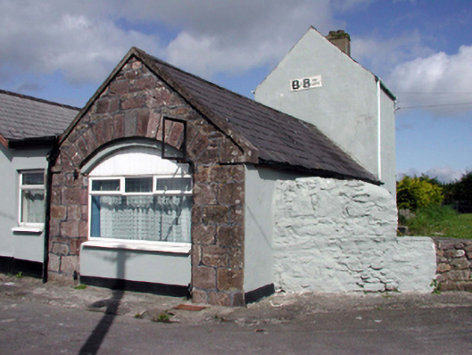
Detached single-bay two-storey gable-fronted pilot station, c.1850, with three-bay single-storey boathouse return to north-west originally having segmental-headed integral carriageway. Renovated and extended, c.1975, comprising seven-bay single-storey parallel wing along side (north-east) elevation with carriageway remodelled to accommodate use as guesthouse. Refenestrated, pre-1999. Pitched slate roofs with clay ridge tiles, rendered chimney stack, cut-stone coping, and replacement plastic rainwater goods, c.1975, on timber eaves. Pitched artificial slate roof to wing with concrete ridge tiles, rendered chimney stack, timber bargeboards, and plastic rainwater goods on timber eaves. Painted rendered walls with coursed squared rubble red sandstone wall to north-west elevation of original block. Square-headed window openings (some shallow segmental-headed window openings to original block) with concrete sills. Replacement timber casement windows, c.1975, to first floor with replacement uPVC casement windows, pre-1999, to remainder. Square-headed door opening with glazed timber panelled door. Segmental-headed carriageway remodelled, c.1975, to accommodate square-headed window opening with concrete sill, c.1975, and replacement uPVC casement window, pre-1999, retaining cut-stone voussoirs over. Sited on Boathouse Quay pier.
A well-composed building of distinctive appearance that is of considerable significance for its associations with the maritime industry in Passage East that has traditionally supported the economy of the locality. Despite alterations in the late twentieth century, including the addition of wing of little inherent architectural merit, much of the form and massing of the original portion remains intact, including the outline of an attractive carriageway incorporating fine stone work. The pilot station remains an attractive feature of the built heritage of Passage East, the two-storey section forming a prominent 'tower'-style landmark in the locality.
From the Buildings of Ireland (National Inventory of Architectural Heritage) record 22807070
This does not grant access. Most recorded buildings are privately owned; view them only from public ground unless the owner allows entry.
Places near here
 Middle QuayPier/jetty · 48 yd
 Boathouse QuayPier/jetty · 51 ydPassageSettlement cluster · 102 ydIvory MemorialMemorial · 642 yd
 Ballyhack Castle (in ruins)Castle, tower house · 820 yd
 Arthurstown BeachBeach / strand · 1384 yd
 Geneva BarracksCastle · 1.5 mi
 Common Whitebeam1.6 mi
 Nook BayBay · 1.6 mi
 Duncannon FortBastioned fort · 2.0 mi
 Duncannon BeachVisitor information · 2.1 mi
 DuncannonBeach / strand · 2.3 mi
Pictures: P L Chadwick, Geograph · CC BY-SA 2.0; Alanna Milbourne, Wikimedia Commons · CC BY-SA 4.0; Humphrey Bolton, Geograph · CC BY-SA 2.0; RTG, Wikimedia Commons · CC BY-SA 4.0; Julie Anne Workman, Wikimedia Commons · CC BY-SA 3.0; Redmond O'Brien, Geograph · CC BY-SA 2.0; Brian Hodge, Wikimedia Commons · CC BY-SA 2.0; Gfox228, Wikimedia Commons · CC BY 3.0
More historic places in County Waterford · All of County Waterford
What do you know about this place?