What is recorded here
From OpenStreetMap (© OpenStreetMap contributors) n3763201783
Places near here
Photo credits
- National Inventory of Architectural Heritage
- Andreas F. Borchert, Wikimedia Commons · CC BY-SA 3.0 de
- Patrice78500, Wikimedia Commons · Public domain
- Kenneth Allen, Wikimedia Commons · CC BY-SA 2.0
- Malene Thyssen, Wikimedia Commons · CC BY-SA 3.0
- Ross, Wikimedia Commons · CC BY-SA 2.0
- Rod Grealish, Geograph · CC BY-SA 2.0
- Jack Bracken, Wikimedia Commons · CC BY-SA 3.0
- Andreas F. Borchert, Wikimedia Commons · CC BY-SA 4.0
- Dr Neil Clifton, Geograph · CC BY-SA 2.0
 Droichead na hAbhna Bige [Owenbeg Bridge]Bridge · 2.0 mi
Explorer Tom Droichead na hAbhna Bige has these really long, squinty stones in the arch that look totally different from the chunky bits holding it up. I bet they were trying to make the bridge look like it’s wearing a very fancy, crooked hat.
 Owenwee BridgeBridge · 2.0 mi
Explorer Tom Owenwee Bridge crosses the river on one broad arch, with long rock-faced stones set around its curve. Built around 1860, it looks almost as if the arch stretched each stone to fit. The rubble abutments stay plain by comparison.
 MoylenanavMountain / peak · 4.3 mi
Explorer Tom Right then, folks, here’s Moylenanav, standing tall in the misty corners of County Donegal. I’m still trying to work out how to pronounce that second syllable without sounding like a startled goose, but it definitely looks like it’s got some character.
 Páirc Naisiúnta Ghleann Bheatha - Glenveagh National ParkNature reserve · 4.7 mi
Explorer Tom Glenveagh National Park follows Lough Veagh through the Derryveagh Mountains, featuring easy trails and historic castle views.
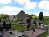 Stackarnagh Abbey GraveyardGraveyard · 4.9 mi
Explorer Tom Stackarnagh Abbey Graveyard has a gatepost detail I keep coming back to: a reused window fragment carved with a fish biting the end of a moulding, with a rough unicorn above it. The survey says the stone probably came from the church's ruined south window. I can enjoy the odd pair without inventing what the medieval carver meant.
 European Beech5.2 mi
Explorer Tom This European Beech in Donegal stands tall, and I bet you need permission to see its secret beauty.
 Glebe House and GalleryHeritage attraction · 5.2 mi
Explorer Tom Glebe House and Gallery lets me visit Derek Hill's home and then see what became of his studio. An 1828 house, art and woodland gardens make quite a three-part outing. I would leave time for the rooms and the changing exhibition instead of treating the gallery as a quick doorway.
 Astelleen Burn WaterfallWaterfall · 5.6 mi
Explorer Tom Astelleen Burn Waterfall, meaning torrent or flood, sloping down three kilometers southwest of Glenveagh Castle is a hidden gem.
.jpeg/250px-Staghall_Mountain_(34093998).jpeg "Photo: Jack Bracken, Wikimedia Commons · CC BY-SA 3.0") Staghall MountainMountain / peak · 5.7 mi
Staghall MountainMountain / peak · 5.7 miExplorer Tom Staghall Mountain has a proper view captured for us, and it looks like a solid old friend standing up in County Donegal. I bet the air up there is crisp enough to make you sneeze before you even start climbing.
 Gartan Ráth Cnó Turas 5 CrossCross · 5.8 mi
Explorer Tom This is *Gartan Ráth Cnó Turas 5 Cross*, the fifth station of a pilgrimage path where the arms are barely perceptible on its weathered face. It stands about 20m south of the graveyard, acting as a humble marker in the reputed birthplace of Colmcille, so take a moment to appreciate how much history is packed into such a small stone.
 Gartan Ráth Cnó Holy WellHoly well · 5.8 mi
Explorer Tom Gartan Ráth Cnó Holy Well sits quietly in a graveyard complex where St. Columbkille was reputedly born. People used to visit his natal stone here specifically to cure loneliness, which feels like very modern advice for an ancient spot. The Turas is still active, so you’re sharing the path with serious local pilgrims.
 Newmills Corn and Flax MillsHeritage attraction · 6.5 mi
Explorer Tom Newmills Corn and Flax Mills has a waterwheel big enough to make me stop and watch the machinery do the hard work. Corn and flax kept different trades moving here. Heritage Ireland's 2026 visitor season has ended, so I would check the next opening date before making the trip.
More mountains and hills in County Donegal · All of County Donegal

What do you know about this place?Tap to add a comment or ask a question