Places near here
Photo credits
- Andreas F. Borchert, Wikimedia Commons · CC BY-SA 4.0
- National Inventory of Architectural Heritage
- Marc Calhoun, Geograph · CC BY-SA 2.0
- Own work, Wikimedia Commons · CC BY-SA 3.0
Explorer Tom Trá Bhéal Doire in County Mayo would teach history by making you walk backwards through the sand until you forgot why you were there in the first place. It’s got a name that sounds like it came from a very serious book about old languages, but it’s really just a beach having a bit of a day. The waves are probably grading your pronunciation and giving you a failing mark every time. Have
Promontory fortPromontory fort, coastal · 787 ydExplorer Tom Promontory fort at Baile Mhic Shéathrúin started after two lads bet it would survive the tide. It didn't really, so they both lost their shirts and their pride. Bring sandwiches, the gulls will thank you.
 Cross Abbey (in Ruins)Religious house, Augustinian canons · 923 yd
Explorer Tom Cross Abbey is an Augustinian canon house that refuses to fall down because it’s too stubborn about its own historical importance. It sits on An Chrois with Annagh Head in the background, looking like it’s waiting for someone to finally get the joke. The canons probably had strict rules, but they clearly forgot to write 'fall over' in the fine print. Grand pla
Trá na CroiseBeach / strand · 1.0 miExplorer Tom Trá na Croise is named after crosses, which makes me think Saint Patrick stopped by, saw this spot, and said 'nah, not for me.' It’s got a certain dramatic flair that only a holy man would appreciate or dismiss. Perfect spot to practise your best tour-guide voice if you’re feeling theatrical.
 pier/jetty1.7 mi
Explorer Tom The pier in Curraghboy was designed by Alexander Nimmo back in the early nineteenth century, when engineers thought sticking things into the water was a good idea. It’s an integral part of Mayo’s heritage, which is a polite way of saying 'it’s still standing.' Look out for seagulls and don’t slip on the wet wood.
 Inishglora Monastic SiteArchaeological place · 2.0 mi
Explorer Tom Inishglora Monastic Site is like the family tree of the island, mostly made up of monks who kept getting distracted by the sea and forgetting to finish building their churches properly on time. It’s got that classic monastic vibe where everything looks peaceful but also slightly chaotic because nobody really knew what they were doing with the layout back then anyway. Perfect detour when the satnav
Inis GluaireIsland · 2.3 miExplorer Tom Inis Gluaire is an island that thinks it’s a mountain but lacks the altitude. The first owner probably just looked at it, shrugged, and said, 'Nah, I’ll take the flat with the balcony instead.' It’s sitting out there looking proud of absolutely nothing, which is a brave look to pull off anywhere. Bring wellies and low expectations, leave delighted.
Barranagh Castle in RuinsCastle, unclassified · 2.7 miExplorer Tom Barranagh Castle in Ruins sits on a storm beach, looking at the modern houses that replaced it with pure, unadulterated disdain for their lack of character and insulation. Tell the kids it's a castle. Close enough.
Inis CaorachIslet · 2.7 miExplorer Tom Inis Caorach sounds like it’s planning its retirement after a long life of being ignored by everyone else. It’s just sitting there in Mayo, looking smug about having no visitors at all. I’d bet it’s got a very specific plan for doing absolutely nothing. Go on a wet day, it suits the mood.
Ceann an EanaighHeadland · 2.7 miExplorer Tom Ceann an Eanaigh was saved by a hero nobody remembers, who probably just pointed in the right direction and left without asking for payment. It’s a headland with a name that sounds like a fancy restaurant nobody can afford, but it’s really just rocks and wind. The story is lost to time, but the vibe remains of someone who knew what they were doing. Pretend it's yours and plan the housewarming
Bawn in Tearmann CaithreachBawn · 2.8 miExplorer Tom Bawn in Tearmann Caithreach would bring a bucket of old stones to a party and call it chic. It’s a walled enclosure that’s mostly just vibes and potential right now. Perfect detour when the satnav has a meltdown.
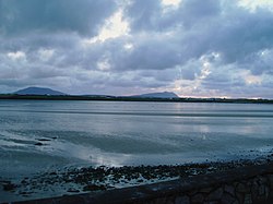 Cuan an Fhóid DuibhBay · 5.3 mi
Explorer Tom Blacksod Bay is wide enough to swallow one of my directions and still have room for the boat. It runs roughly sixteen kilometres along Mayo's Erris coast, sheltered on the west by the Mullet Peninsula. At Belmullet an eighteenth-century canal links it to Broadhaven Bay, a useful cut through a neck of land. Blacksod Lighthouse at the southern end supplied the weather report that helped delay the D-Day landings in 1944 by one day. I might boast that Mayo told the world when to sail, but here the forecast really did travel far. The bay has small islands and working water as well as postcard views. Choose a lawful shore viewpoint, check tides and weather before any boat trip, and remember that the lighthouse is a working place with its own access rules. Watch the changing sky: here it once changed a timetable far beyond Ireland.
More memorials and graveyards in County Mayo · All of County Mayo

What do you know about this place?Tap to add a comment or ask a question