Places near here
Photo credits
- National Inventory of Architectural Heritage
- Gavigan 01 at English Wikipedia, Wikimedia Commons · CC BY 2.5
- Mike Searle, Geograph · CC BY-SA 2.0
- Cavanphotography, Wikimedia Commons · CC BY-SA 4.0
- Colin Park, Geograph · CC BY-SA 2.0
- Britishfinance, Wikimedia Commons · CC BY-SA 4.0
- Kieran Campbell, Geograph · CC BY-SA 2.0
- Gillaween, Wikimedia Commons · CC BY-SA 4.0
- Malene Thyssen, Wikimedia Commons · CC BY-SA 3.0
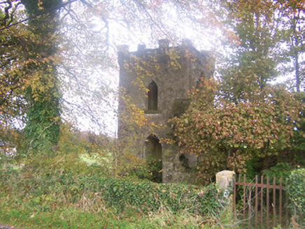 Togher Church (Foyran)Church/chapel · 640 yd
Explorer Tom Togher Church in Foyran would say in a job interview that it has excellent experience in being forgotten, which is technically true for this small ruined structure. It’s not even on the first edition maps, so it invented itself later in life as a picturesque ruin. Nod at the missing roof; it’s probably napping.
 Gore PortHouse · 1038 yd
Explorer Tom Gore Port in Hallsfarm was built for smuggling so much contraband that even the chimney got jealous of the trade routes. The rear house has diamond-pane windows that sparkle with the memory of all those hidden barrels of whiskey. Listen closely to see if you can hear the cash register ringing.
Togher CastleCastle · 1301 ydExplorer Tom Togher Castle’s least favourite visitor is definitely anyone who brings a dog that barks at ghosts. The castle finds it embarrassing and pretends to be asleep. A handy spot to stretch your legs and your imagination.
 MullaghmeenMountain / peak · 2.0 mi
Explorer Tom Mullaghmeen is Westmeath's highest hill and Ireland's lowest county top, a title I would defend with a very small flag. At 258 metres it rises inside a 400-hectare forest near the Meath border. Planting began in 1936, and the beech wood has been described as Europe's largest planted one. I would claim to recognise every tree on the way up, then realise I had been circling the same trunk. Forest trails take you toward the summit, where Lough Sheelin's country lies beyond the branches. Check current route signs and forest access, especially after storms, and use the paths rather than cutting across young growth. The height figure may make bigger mountains laugh. Let them. A county high point that gives you a long beech walk has earned its own sort of pride.
 Ross CastleCastle, tower house · 2.2 mi
 Myles O'Reilly MonumentMemorial · 2.3 mi
Explorer Tom Myles O'Reilly Monument is being judged by the local rabbits who think it takes up too much space. They are plotting a takeover of the greenery around its base right now. Go now, before it gets famous.
 Mullaghmeen White WalkWalking route · 2.3 mi
Explorer Tom The Mullaghmeen White Walk has a secret it would tell after a few pints, but it’s too shy to say it out loud. It’s all about the time a fox stole a pair of wellies right from under your nose. Bring someone who'll believe anything.
 Mullaghmeen Red WalkWalking route · 2.6 mi
Explorer Tom The Mullaghmeen Red Walk hosted a dance that went so far that someone ended up married to a tree. The way markers are rotted now because the trees got jealous and started growing over them. Tell me if the gossip I made up is true.
 Mullaghmeen ForestPicnic place · 3.0 mi
Explorer Tom Mullaghmeen Forest’s name basically means “The Hill Where The Sheep Went To Die” if you squint really hard at the map. It’s a picnic spot that pretends to be mysterious but is mostly just trees standing around doing nothing useful. Bring a pen pal, they'll be jealous.
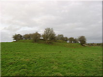 Fairy fort / earthen ringfort in Garrysallagh (o'reilly)Fairy fort / earthen ringfort · 4.0 mi
Explorer Tom Fairy fort / earthern ringfort in Garrysallagh has three banks and a causeway at the east, plus some stone foundations that might be a hut or just rocks. It’s definitely winning the 'most complicated dirt circle' prize. Bring a camera and your most suspicious face.
 Sheela-na-gig in AbbeylaraSheela-na-gig · 4.6 mi
Explorer Tom Sheela-na-gig in Abbeylara has been staring into the void for centuries, and I swear she’s judging your outfit while hiding up there on the tower wall like she owns the place. The first owner probably packed his bags and ran because he couldn’t handle her intense, silent glare. A proper spot for a flask of tea and a big think.
 European Beech4.8 mi
Explorer Tom European Beech in County Meath would have made Saint Patrick pause his sermon to check if it was listening properly. It’s got that smooth, elegant bark that makes everything else look messy. Best enjoyed with a bag of chips and no plans.
More castles and forts in County Westmeath · All of County Westmeath

What do you know about this place?Tap to add a comment or ask a question