Places near here
Photo credits
- Joseph Mischyshyn, Geograph · CC BY-SA 2.0
- National Inventory of Architectural Heritage
- Willow, Wikimedia Commons · CC BY 2.5
- dougf, Wikimedia Commons · CC BY-SA 2.0
- Graham Horn, Geograph · CC BY-SA 2.0
- Bob Embleton, Wikimedia Commons · CC BY-SA 2.0
- Peter Gerken, Wikimedia Commons · CC BY-SA 2.0
- N Chadwick, Geograph · Creative Commons Attribution-ShareAlike 2.0
- Chris06, Wikimedia Commons · CC BY-SA 4.0
- Didier Descouens, Wikimedia Commons · CC BY-SA 4.0
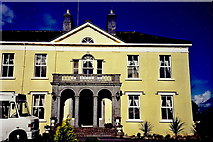 Castledaly ManorCountry house · 342 yd
Explorer Tom Castledaly Manor is an Italianate beauty that started because two lads made a bet in the pub over who could build the fanciest porch. It’s got thirty-five acres of woodland to hide its secrets from anyone who gets too nosy. Keep your eyes on the bracketed eaves and try not to fall for its charm.
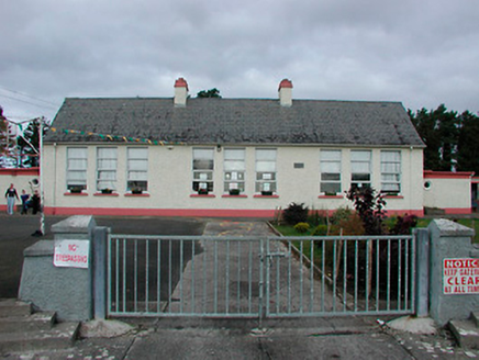 Kilcleagh National SchoolSchool · 372 yd
Explorer Tom Kilcleagh National School is a modest rural school with a slender water tower that looks like it’s trying to reach the clouds. It was built to a standard design, but it still manages to look pleasantly composed and unassuming. The extension at the back didn’t ruin the vibe; it just added more space for learning. Wave to the tower from the road!
 European ash2.2 mi
Explorer Tom European ash in County Westmeath is standing tall after a local priest lost a bet about how many leaves it has and now refuses to speak to him. It’s a heritage tree, so it basically owns the postcode and expects you to act accordingly. Tell your mates you found it first.
 Esker CastleCastle, tower house · 3.0 mi
Explorer Tom Esker Castle in County Offaly had a prophecy that it would one day be covered in trees, and look, it has. It sits at the west end of an esker ridge, overlooking a stream called The Brook with serious boundary vibes. The medieval road connection to Athlone means it’s seen more traffic than you’d think possible. Bring someone who'll believe anything.
Dún na SíMuseum · 3.2 miExplorer Tom Dún na Sí is hiding its fairy secrets behind museum curtains. Rumor has it the local goat refused to eat hay because it looked too much at the curator. Hum something sad nearby, it adds atmosphere.
 CastleCastle, unclassified · 6.4 mi
Explorer Tom Cox's Castle in Athlone makes a weird groaning sound at night, probably because it’s thinking about its past life. It used to be on St. George's Lane before getting lost in the shuffle of history. It’s got that ‘I was here’ energy but no receipt. Listen closely if you’re brave enough.
 Rock art in ClonfinloughRock art · 6.8 mi
Explorer Tom Rock art in Clonfinlough claims to be older than your granddad’s bad haircut, and I believe it. It’s got holes from water and lines from fancy humans. Perfect spot to practise your best tour-guide voice.
 Siege of AthloneSiege · 7.1 mi
Explorer Tom Another Siege of Athlone event is telling the place that replaced it to stop acting so modern, as if concrete is superior to old stone walls. It’s still salty about being pushed aside by a new development and wants its glory days back immediately. Dare you to say hello to it out loud.
 ClonmacnoiseArchaeological place · 8.2 mi
Explorer Tom Clonmacnoise in County Offaly has one least favourite visitor: the guy who keeps asking if the stones are hot to touch. He does it every single time, ruining the ancient atmosphere for everyone else around him. The place just sighs collectively whenever he starts walking towards the ruins. Give it a pat on the way past, it's had a long life.
 Graveyard in ClonmacnoiseGraveyard · 8.2 mi
Explorer Tom Clonmacnoise graveyard is packed with seven churches and six high crosses in one spot. St. Ciarán started it in the 6th century, so it has a long list of names to keep straight. Bring biscuits, every good story needs biscuits to go with the legends.
.jpg/250px-2007_Clonmacnoise_Cathedral_(1).jpg "Photo: Chris06, Wikimedia Commons · CC BY-SA 4.0") Cathedral or Temple Mc Dermot (in Ruins)Cathedral · 8.2 mi
Cathedral or Temple Mc Dermot (in Ruins)Cathedral · 8.2 miExplorer Tom Cathedral Mc Dermot at Clonmacnoise has four building phases, which means the architect had serious commitment issues. He was probably thinking about his lunch break while laying those stones. Bring your worst joke, the place has heard worse.
 Hawthorn8.7 mi
Explorer Tom Hawthorn in County Offaly would survive a zombie attack by simply standing still until they get bored and leave. Its thorns are basically tactical deterrents. Visit, then text me what you think. I'll pretend to read it.
More archaeology and monuments in County Westmeath · All of County Westmeath

What do you know about this place?Tap to add a comment or ask a question