What is recorded here
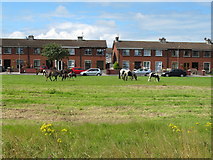
In reclaimed grassland, with stream marking townland boundary with Srahane West immediately to E. Outline of circular-shaped area (approx. diam. 26m; ext. diam. 53m) defined by a scarp and wide fosse or moat (approx. Wth 13m) visible on Digital Globe orthophoto taken 2011-13 and earlier OSi orthoimages. Outline of monument clearly visible on Google Earth orthoimage taken 05/04/2006. On this image the fosse appears to be waterlogged with evidence of rushes in the wet fosse or moat. The location on wet marshy land adjacent to a stream with wide waterlogged fosse suggests a prehistoric ritual site in the barrow or henge tradition rather than that of a medieval settlement or ringfort. Cropmarks of old watercourse is visible to N of monument with channels feeding from old stream into fosse or moat of the monument which is clearly visible on Google Earth orthoimage taken 06/02/2018. See attached Google Earth orthophotos taken 05/04/2006, 25/03/2017 and 06/02/2018.
In reclaimed grassland, with stream marking townland boundary with Srahane West immediately to E. Outline of circular-shaped area (approx. diam. 26m; ext. diam. 53m) defined by a scarp and wide fosse or moat (approx. Wth 13m) visible on Digital Globe orthophoto taken 2011-13 and earlier OSi orthoimages. Outline of monument clearly visible on Google Earth orthoimage taken 05/04/2006. On this image the fosse…
From the National Monuments Service (Archaeological Survey of Ireland) record LI014-172
The monument record does not grant public access. Check the route and ask the landowner before entering private land.
- What survives
- Recorded monument
Places near here
Photo credits
- National Inventory of Architectural Heritage
- Ronnie Nijboer, Wikimedia Commons · CC0
- Garry Dickinson, Wikimedia Commons · CC BY-SA 2.0
- Garry Dickinson, Geograph · CC BY-SA 2.0
- Hywel Williams, Geograph · CC BY-SA 2.0
- David Hawgood, Geograph · CC BY-SA 2.0
 Ahabeg HouseHouse · 905 ydGrave YardGraveyard · 907 yd
 Highpark HouseCountry house · 1235 ydIndicatedChildren's burial ground · 1293 yd
 Catholic Church of the Immaculate Heart of MaryChurch/chapel · 1493 yd
 Carrigparson HouseHouse · 1606 yd
 Wych Elm1.9 miGraveyard in AbingtonGraveyard · 4.0 mi
_-_geograph.org.uk_-_6519496.jpg/250px-Castles_of_Munster,_Castle_Troy,_Limerick_(1)_-_geograph.org.uk_-_6519496.jpg "Photo: Garry Dickinson, Wikimedia Commons · CC BY-SA 2.0") Castle Troy (in ruins)Castle, tower house · 4.1 mi
Castle Troy (in ruins)Castle, tower house · 4.1 mi CastleCastle, motte and bailey · 4.4 mi
 Limerick Seamen's MemorialMemorial · 5.7 mi
 King's IslandIsland · 5.8 mi
More archaeology and monuments in County Limerick · All of County Limerick
What do you know about this place?