What is recorded here
From the Northern Ireland Sites and Monuments Record record ANT052:157
Places near here
Picture notes
- Computer-made picture. It does not show this playground.
- Rossographer, Geograph · CC BY-SA 2.0
- Kenneth Allen, Geograph · CC BY-SA 2.0
- Ross, Wikimedia Commons · CC BY-SA 2.0
- Rossographer, Wikimedia Commons · CC BY-SA 2.0
- Albert Bridge, Wikimedia Commons · CC BY-SA 2.0
- Computer-made picture. It does not show this garden.
- Puffer, Geograph · Creative Commons Attribution-ShareAlike 2.0
- Albert Bridge, Geograph · CC BY-SA 2.0
- David Trochos at English Wikipedia, Wikimedia Commons · Public domain
- Eric Jones, Geograph · Creative Commons Attribution-ShareAlike 2.0
 Children's playground1469 ydComputer-made picture. It does not show this playground.
Explorer Tom This quiet Children's playground in County Antrim seems to be waiting patiently for its next big splash of fun.
 Woodburn ForestForest · 1.6 mi
Explorer Tom Woodburn Forest near Carrickfergus has reservoirs you can see from a distance, like a quiet mirror reflecting the sky above County Antrim.
 North Carn ForestForest · 1.7 mi
Explorer Tom North Carn Forest faces west-southwest according to the map, so maybe it catches the sunset in a way that makes the trees glow gold.
_-_geograph.org.uk_-_652849.jpg/250px-County_Antrim_War_Memorial_(Knockagh_Monument)_-_geograph.org.uk_-_652849.jpg "Photo: Ross, Wikimedia Commons · CC BY-SA 2.0") Knockagh MonumentMonument · 2.8 mi
Knockagh MonumentMonument · 2.8 miExplorer Tom Perched high above Greenisland, the Knockagh Monument in County Antrim proudly displays its inscription while offering breathtaking views of Belfast Lough.
The County Antrim War MemorialMemorial · 2.8 miExplorer Tom The County Antrim War Memorial at Knockagh stands as a solemn tribute to those who served and sacrificed for peace.
_-_geograph.org.uk_-_5247773.jpg/250px-The_Ulster_Bank,_Ballyclare_-_January_2017(1)_-_geograph.org.uk_-_5247773.jpg "Photo: Albert Bridge, Wikimedia Commons · CC BY-SA 2.0") Ulster BankBank · 3.2 mi
Ulster BankBank · 3.2 miExplorer Tom Ballyclare’s Ulster Bank branch is a Grade B2 listed structure that likely secured local wealth for decades.
 Memorial GardenGarden · 3.6 miComputer-made picture. It does not show this garden.
Explorer Tom This Memorial Garden might be particularly well-maintained, with neat hedges and quiet corners for contemplation in the heart of Antrim.
 Multiperiod Church & Graveyard with Well: Rath Sithe, Rashee, or Rassci in RasheeMultiperiod Church & Graveyard with Well: Rath Sithe, Rashee, or Rassci · 4.5 mi
Explorer Tom Rath Sithe in Rashee is a multiperiod site with a church, graveyard, and well, sometimes called the Four Corners Graveyard nearby.
 Carnmoney HillMountain / peak · 4.6 mi
Explorer Tom Carnmoney Hill reaches 231 metres above sea level near Belfast, offering potential views across the lough on clear days.
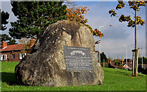 US RangersMemorial · 4.8 mi
Explorer Tom This stone marks US Rangers who camped at Sunnylands during WWII. A quiet nod to history.
 Siege of CarrickfergusSiege · 4.8 mi
Explorer Tom Picture the Siege of Carrickfergus: imagine defenders holding the castle’s north-east side against determined besiegers.
 Medieval Parish Church, Post-med. & Modern Church & Graveyard: St Nicholas' Church, St Nicholas of Cragfergus in CarrickfergusMedieval Parish Church, Post-med. & Modern Church & Graveyard: St Nicholas' Church, St Nicholas of Cragfergus · 4.9 mi
Explorer Tom St Nicholas’ Church in Carrickfergus spans medieval to modern times, showing you a long, layered story right here.
More archaeology and monuments in County Antrim · All of County Antrim

What do you know about this place?Tap to add a comment or ask a question