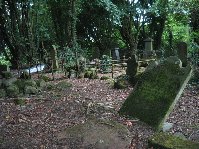
What is recorded here
Rath Sithe in Rashee, County Antrim, has stood through early Christian and medieval times, its name shifting between Rashee and Rassci like a breath held too long. The church and graveyard still hold their stones, but the well at their heart drinks more than water; it takes memories and returns them changed. People may have prayed there, buried their dead, and forgotten why the place felt hungry. What is certain is that Rath Sithe remembers every name spoken over it, even the ones spoken to leave them behind.
The official Northern Ireland record identifies this as MULTIPERIOD CHURCH & GRAVEYARD with WELL: RATH SITHE, RASHEE, or RASSCI. Recorded period: E.CHRIST.; MEDIEVAL; UNCERTAIN. The official map point was placed at the centre of the recorded archaeological site from the source map reference.
The monument record does not grant public access. Check the route and ask the landowner before entering private land.
- What survives
- Recorded monument
Places near here
 ENCLOSURE? in RasheeENCLOSURE? · 118 yd
 ENCLOSURE in RasheeENCLOSURE · 468 yd
 FORTIFIED HOUSE: CASTLE HILL in DunamoyFORTIFIED HOUSE: CASTLE HILL · 1128 yd
.jpg?width=1280) Ballyclare Town HallTown Hall · 1.5 mi
Ballyclare Town HallTown Hall · 1.5 mi_-_geograph.org.uk_-_5247773.jpg?width=1280) Ulster BankBank · 1.6 mi
Ulster BankBank · 1.6 mi Big CollinMountain / peak · 3.3 mi
 Ballyboley ForestForest · 3.7 mi
 C17th CASTLE on MONASTIC SITE : ORDER of ST. JOHN OF JERUSALEM, UPTON CASTLE, UPTON MAUSOLEUM, HUGH DE LOGAN'S TOWN in TemplepatrickC17th CASTLE on MONASTIC SITE : ORDER of ST. JOHN OF JERUSALEM, UPTON CASTLE, UPTON MAUSOLEUM, HUGH DE LOGAN'S TOWN · 5.3 mi
 North Carn ForestForest · 5.9 mi
 Sentry Hill Historic HouseMuseum · 6.0 mi
 CarnearnyMountain / peak · 6.0 mi
 O'Haughan's CaveCave · 7.0 mi
Other information
Photo: Puffer · Creative Commons Attribution-ShareAlike 2.0