What is recorded here
Baravore Valley Lower is recorded as a cliff in County Wicklow.
From OpenStreetMap (© OpenStreetMap contributors) w1013749050
Places near here
AbseilCliff · 892 yd BenleaghMountain / peak · 1503 ydLugduffMountain / peak · 1.4 miMiners' VillageRuins · 2.5 miBattle of GlenmalureMajor battlefield · 2.6 miGlendaloughViewpoint · 2.7 miSaint Kevin's BedRuins · 3.5 miPoulanass WaterfallWaterfall · 3.8 miWicklow GapMountain pass · 3.9 miCloigtheachRound tower · 4.6 miGlendalough Round TowerHeritage attraction · 4.6 miStone CrossCross, High cross · 4.6 mi
 BenleaghMountain / peak · 1503 yd
 LugduffMountain / peak · 1.4 mi
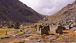 Miners' VillageRuins · 2.5 mi
 Battle of GlenmalureMajor battlefield · 2.6 mi
 GlendaloughViewpoint · 2.7 mi
 Saint Kevin's BedRuins · 3.5 mi
 Poulanass WaterfallWaterfall · 3.8 mi
 Wicklow GapMountain pass · 3.9 mi
 CloigtheachRound tower · 4.6 mi
 Glendalough Round TowerHeritage attraction · 4.6 mi
 Stone CrossCross, High cross · 4.6 mi
Pictures: Britishfinance, Wikimedia Commons · CC BY-SA 4.0; Joe King, Wikimedia Commons · CC BY-SA 3.0; The Vicious Chicken of Bristol, Wikimedia Commons · CC BY-SA 4.0; XeresNelro, Wikimedia Commons · CC BY-SA 4.0; Jan-Herm Janßen, Wikimedia Commons · CC BY-SA 3.0; 1ivia, Wikimedia Commons · CC BY 2.0; Pampuco, Wikimedia Commons · CC BY-SA 4.0; Rafesmar, Wikimedia Commons · CC BY-SA 4.0; No machine-readable author provided. Haraldius~commonswiki assumed (based on copyright claims)., Wikimedia Commons · CC BY-SA 2.5; Millars, Wikimedia Commons · CC BY-SA 4.0
More cliffs, bays and coast in County Wicklow · All of County Wicklow
What do you know about this place?