
What is recorded here
From OpenStreetMap (© OpenStreetMap contributors) n3815424241
Places near here
Photo credits
- National Inventory of Architectural Heritage
- Didier Descouens, Wikimedia Commons · CC BY-SA 4.0
- Kenneth Allen, Geograph · CC BY-SA 2.0
- Jonathan Wilkins, Wikimedia Commons · CC BY-SA 2.0
- Dean Molyneaux, Geograph · CC BY-SA 2.0
- David Dixon, Geograph · CC BY-SA 2.0
- Kenneth Allen, Wikimedia Commons · CC BY-SA 2.0
- louise price, Wikimedia Commons · CC BY-SA 2.0
 Aghadullagh BridgeBridge · 1.0 mi
Explorer Tom Aghadullagh Bridge spans the Ballintra River on two stone arches. The account says a corn mill may once have stood just west of it; an old survey map shows the mill, but its connection to the bridge is uncertain. A bridge beside a vanished neighbour: I would like to see them together on that map.
 bridge1.2 mi
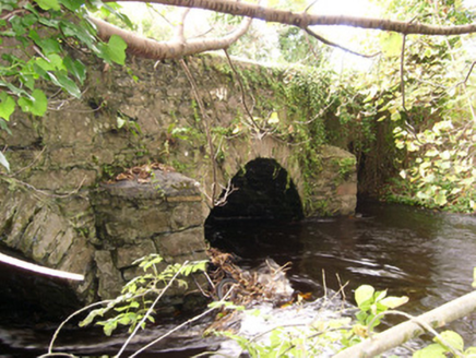
Explorer Tom Bridge in Ballintra wears sharp V-profile cutwaters on its piers that look like grumpy eyebrows. I picture them in c.1790 narrowing their stone eyes, daring the Ballintra River to splash higher than they expected. Do those rough-hewn brows ever blink?
 Hawthorn1.8 mi
Explorer Tom Hawthorn in County Donegal is having a bit of a tantrum about needing permission to be seen. I'm told it's fancy stuff, but honestly, just hugging it might scare the locals off. Give it a wink for me.
 MurvaghOfficial bathing water · 3.7 mi
Explorer Tom Murvagh Beach has a wartime lookout hut that Joy Browne, writing for Donegal tourism, remembers playing in as a child. She says erosion has since sunk it into the sand and made entry impossible. A lookout hut retiring by burying its feet is theatrical enough for me; I would leave it to its rest.
 Sheebarran RingfortFairy fort / earthen ringfort · 3.9 mi
Explorer Tom Sheebarran Ringfort is a massive circular space with a ditch so wide it could swallow a small car. It sits on the crest of a ridge with excellent views, making it the perfect spot for a dare to see how far you can shout. Use it as a yarn about being the king of the hill without actually wearing a crown.
 RossnowlaghOfficial bathing water · 4.1 mi
Explorer Tom Rossnowlagh seems determined to be a whole journey rather than one beach. Donegal tourism runs it from Coolmore’s cliffs to Carrickfad’s rock. I would need a bigger postcard for that stretch of golden sand; the surfers have probably had that problem for years.
 Rooney's IslandIslet · 4.5 mi
Explorer Tom Rooney's Island was once home to the O'Maoldory Clan, who ruled as Kings of Tir Conaill. I imagine a very serious coronation ceremony taking place on a patch of ground that barely fits a picnic blanket.
 Standing stone in Townparks (ballyshannon Ed)Standing stone · 4.9 mi
Explorer Tom Standing stone in Townparks is roughly 1.3m high and set on rock outcrop, possibly just a natural feature rather than a true standing stone. Locals say it marks a fording place of the river Erne, but with 'cat's paw' markings that might be natural too, it’s hard to know if it’s a guide or just a grumpy rock.
 Dicey Reilly’sPub · 5.0 mi
Explorer Tom Dicey Reilly’s is on Market Street, so expect a crowd that knows exactly which side of the argument they're winning. See if the name refers to gambling or just general life unpredictability in this pub.
 Max BarPub · 5.0 mi
Explorer Tom Max Bar is also on Market Street, right next door to other pubs, suggesting a fierce rivalry over who has the best pints. Ask the locals which one they prefer and why it's superior to its neighbours.
 Kilbarron Old Church GraveyardGraveyard · 5.0 mi
Explorer Tom Kilbarron Old Church Graveyard features a 15th or 16th century ruin with a 2.4m high E gable that has no window at all. That is quite the dramatic lighting choice for a place meant to let in some divine brightness.
 Rory GallagherMemorial · 5.1 mi
Explorer Tom Rory Gallagher memorial? That's just a guy who played guitar, right? Well, sort of. Go back in winter, it's a different animal when the wind is howling and you're pretending you know what you're doing.
More mountains and hills in County Donegal · All of County Donegal

What do you know about this place?Tap to add a comment or ask a question