What is recorded here
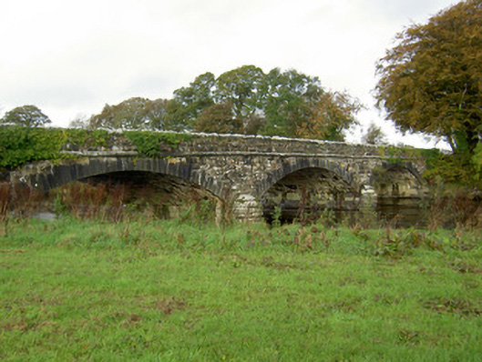
Triple-arch limestone road bridge, dated 1866, over River Blackwater. Snecked rubble stone walls having rock-faced copings to parapet walls and dressed string courses to elevations over segmental arches having dressed tooled voussoirs. Date plaque to east parapet. Ordnance survey benchmark to west parapet wall. Carved U-cutwaters to piers.
This solidly constructed and well-designed bridge is a fine example of the skilled engineering and stone-crafting of the late nineteenth century. Its shallow segmental arches and U-cutwaters are typical features of bridges of its time and the large blocks used in its construction add to the solid appearance.
This does not grant access. Most recorded buildings are privately owned; view them only from public ground unless the owner allows entry.
Places near here
 Leaders BrBridge · 327 yd
 AllowdaleCountry house · 635 yd
 IndicatedCrannog · 1548 yd
 Man-made underground passage in BanteerMan-made underground passage · 1629 yd
 CastleCastle, unclassified · 1.2 mi
 Clonmeen Court (Site of)House, fortified house · 1.4 mi
 St Fursey's WellSpring · 1.4 mi
 Kanturk CastleHeritage attraction · 1.9 mi
 Mount Hillary - Father Murphy LoopWalking route · 2.4 mi
 Mount Hillary - Knightfield LoopWalking route · 2.5 mi
 Hanna SheehyMemorial · 2.8 mi
 Battle of Knocknaclashybattle · 3.0 mi
Other information
Photo: National Inventory of Architectural Heritage · Website use allowed for educational or private purposes with source credit