
What is recorded here
From OpenStreetMap (© OpenStreetMap contributors) n3659281719
Places near here
Picture notes
- Computer-made picture. It does not show this monument.
- Computer-made picture. It does not show this mountain top.
- Kenneth Allen, Geograph · Creative Commons Attribution-ShareAlike 2.0
- Somerville, Boyle T. (Henry Boyle Townshend), 1863-1936, Wikimedia Commons · Public domain
- National Inventory of Architectural Heritage
- Kenneth Allen, Geograph · CC BY-SA 2.0
- Ronnie Nijboer, Wikimedia Commons · CC0
- Computer-made picture. It does not show this playground.
- sarah gallagher, Geograph · CC BY-SA 2.0
 Hut site in CreeveoughterHut site · 1741 ydComputer-made picture
Explorer Tom Hut site in Creeveoughter is another piece of the puzzle in this area, suggesting a community that really put down roots. I wonder what their daily routine looked like, maybe waking up to the smell of peat smoke. It’s a simple name for a place that must have felt very significant to its original inhabitants.
 Structure in CreeveoughterStructure · 1741 ydComputer-made picture
Explorer Tom Structure in Creeveoughter is a boggy jumble of hut banks and stone lines where Neolithic people once picked up flints. It’s not a gallery grave, but those paired rows look like a very lazy ancient fence line.
 CraigcannonMountain / peak · 1.1 miComputer-made picture
Explorer Tom Craigcannon sounds like something that goes boom, but it’s just sitting there quietly. Probably plotting world domination from the top. Bring wellies and low expectations, leave delighted, and don't look for the cannon, it’s imaginary anyway.
 Saint Catherine's Catholic ChurchChurch/chapel · 1.3 mi
Explorer Tom Saint Catherine's Catholic Church has two date stones, both saying 1792; one also names RDJ McElwee. The front has battlements and pinnacles. I expected a church, then found a little castle shape too. Now I want to know what those initials stood for.
 Croaghan HillMountain / peak · 1.5 mi
Explorer Tom Croaghan Hill hides a passage tomb that dwarfs its own defensive walls. The enclosure is barely a metre high, yet it shelters a mound three metres high and twenty-one metres across. I bet the ancient builders felt rather small inside their own home.
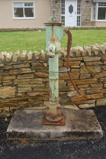 water pump1.9 mi
Explorer Tom Water pump in Tirlaydan has a cow's-tail handle, though the whole thing is cast iron and needs no feeding. Erected around 1900, it recalls the days before mains water reached the area. That handle earns its silly name.
 Rathmullan Wood Nature ReserveNature reserve · 2.9 mi
Explorer Tom Rathmullan Wood Nature Reserve is keeping itself quite busy in County Donegal. It's just another nature reserve spot, really, but it is a handy spot to stretch your legs and your imagination at the same time.
 Wych Elm2.9 mi
Explorer Tom Wych Elm in County Donegal is just an elm, but it’s got presence, like it’s waiting for you to say the right thing. It’s quiet, steady, and probably thinking about photosynthesis while you’re worrying about parking. Dare you to say hello to it out loud, see if the leaves rustle back.
 Belle's KitchenCafé · 3.2 mi
Explorer Tom Belle's Kitchen sounds like a grandmother who knows your secrets and serves pie. It's in Donegal, where comfort food saves lives. Go get fed and listen to Belle tell you about her garden gnomes.
 An Bonnán BuíRestaurant · 3.3 mi
Explorer Tom An Bonnán Buí is a restaurant with a name that means 'The Yellow Boat' or something similar. Probably serving food that tastes like the ocean floor. Find it and see if the boat metaphor holds up in reality!
 Children's playground3.3 miComputer-made picture
Explorer Tom Children's playground in County Donegal hits different if you’re hungover and holding a sausage roll. It’s the only way to appreciate the sheer chaos of this lovely spot. Best seen with a hangover and a sausage roll.
 Rough IslandIslet · 3.7 mi
Explorer Tom Another Rough Island in County Donegal, because apparently they needed a sequel to their first act. It sits there looking bored near Mulroy Bay. Ten minutes here and you'll have a yarn for the pub.
More mountains and hills in County Donegal · All of County Donegal

What do you know about this place?Tap to add a comment or ask a question