
What is recorded here
From OpenStreetMap (© OpenStreetMap contributors) n332373397
Places near here
Photo credits
- Somerville, Boyle T. (Henry Boyle Townshend), 1863-1936, Wikimedia Commons · Public domain
- National Inventory of Architectural Heritage
- louise price, Geograph · CC BY-SA 2.0
- Kenneth Allen, Geograph · CC BY-SA 2.0
- sarah gallagher, Geograph · CC BY-SA 2.0
- Ronnie Nijboer, Wikimedia Commons · CC0
- Willie Duffin, Wikimedia Commons · CC BY-SA 2.0
 Druid's AltarMegalithic structure · 1.5 mi
Explorer Tom Druid's Altar is a large tilted slab resting on three low stones near Croaghan Hill. The survey says it is not a megalithic tomb and cannot settle whether people placed it or nature did. That uncertainty is the story I want to keep, rather than appointing a druid without a record.
 Croaghan HillMountain / peak · 1.6 mi
Explorer Tom Croaghan Hill hides a passage tomb that dwarfs its own defensive walls. The enclosure is barely a metre high, yet it shelters a mound three metres high and twenty-one metres across. I bet the ancient builders felt rather small inside their own home.
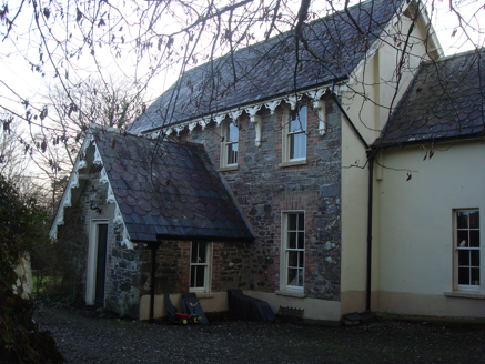 The VicarageRectory/glebe/vicarage/curate's house · 1.8 mi
Explorer Tom The Vicarage in Glenalla has a scalloped and squared banded slate roof that looks like a giant, very crunchy biscuit. I picture it trying to catch crumbs from the air while pretending to be dignified next to the river. Did it bake itself in 1870 or is it still rising?
 Glenalla Standing StoneStanding stone · 1.8 mi
Explorer Tom Glenalla Standing Stone is a 1.4m high monolith with a base width of 1.2m, sitting on the northwest edge of some high ground in rough pasture. It’s quite the sturdy fellow for such a remote spot, standing proud despite its modest dimensions. I reckon it’s been keeping watch over that hillside long enough to have seen every cloud that ever drifted past.
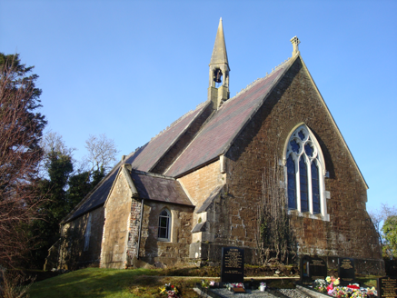 Saint Columbkille's Church (Aughnish)Church/chapel · 1.8 mi
Explorer Tom An older survey described Saint Columbkille's Church (Aughnish) with a bellcote perched where the nave meets the chancel. What a place to put a bell! I picture the spire wearing it like a tall hat and trying not to ring at the birds.
 McGinley'sPub · 2.3 mi
Explorer Tom McGinley's on Main Street has a guy who swears he saw a leprechaun pay his tab. He never left, probably still polishing glasses that aren't there in the back room. Wave at the cows, they're the real locals.
 The Village InnPub · 2.3 mi
Explorer Tom The Village Inn sounds like it contains an actual village, but it’s just a pub on Main Street. Ask the bartender if he knows the local king; he probably doesn’t. Stick around for the light changing, it's a show.
 Rough IslandIslet · 2.7 mi
Explorer Tom Another Rough Island in County Donegal, because apparently they needed a sequel to their first act. It sits there looking bored near Mulroy Bay. Ten minutes here and you'll have a yarn for the pub.
 Wych Elm2.9 mi
Explorer Tom Wych Elm in County Donegal is just an elm, but it’s got presence, like it’s waiting for you to say the right thing. It’s quiet, steady, and probably thinking about photosynthesis while you’re worrying about parking. Dare you to say hello to it out loud, see if the leaves rustle back.
 Rathmullan Wood Nature ReserveNature reserve · 3.0 mi
Explorer Tom Rathmullan Wood Nature Reserve is keeping itself quite busy in County Donegal. It's just another nature reserve spot, really, but it is a handy spot to stretch your legs and your imagination at the same time.
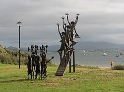 Flight of the EarlsSculpture · 3.8 mi
Explorer Tom Flight of the Earls sculpture in County Donegal is mid-air and absolutely refusing to land on my schedule. I’m pretty sure they’re plotting something grand from up there. Bring your worst joke, because this place has heard much worse.
 RathmullanOfficial bathing water · 3.8 mi
Explorer Tom Rathmullan Beach starts at the pier and keeps strolling past Kinnegar toward the Glebe outcrop. If sand could wear walking boots, this strip would be lacing them up. A 2019 Lough Swilly report also notes otters among the wildlife; I would leave any real otter sighting to patience and luck.
More mountains and hills in County Donegal · All of County Donegal

What do you know about this place?Tap to add a comment or ask a question