What is recorded here
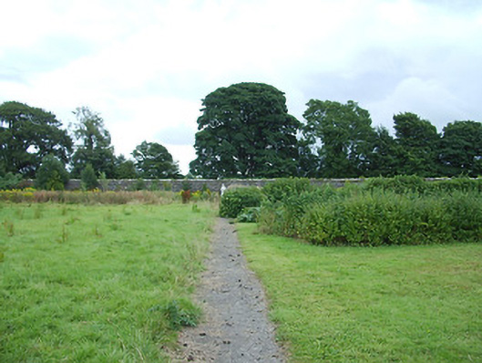
Walled garden on sub-rectangular plan serving Ardagh House (13312039), established c. 1760. Random rubble stone, snecked stone, and brick walls enclosing a formally laid out garden. Coursed dressed stone gate piers (on square-plan) to west elevation, with wrought-iron double leaf gates. Bell pull mechanism adjacent to main entrance, which consists of a handle to the exterior of the garden that sounds a bell set on the interior of the garden when pulled. Pedestrian wrought-iron gate set in wall to south. Glasshouse built against the enclosing wall to north. Some fruit trees and bushes are still in-situ. Located to the east and northeast of the main house and to the northeast of Ardagh.
This substantial walled garden retains much of its early character and form. The boundary walls and gateways are well built, and illustrate the attention to detail that was afforded to even functional structures within a large demesne. Retention of attractive features such as the bell pull augments the significance of the site, and allow for a sense of its history to remain. Its scale is testament to the former size of the Fetherston estate and it provides an interesting insight into the extensive resources needed to run and maintain a large country estate in Ireland during the nineteenth century. The north end of the walled in enclosure was in use as a kitchen garden and/or orchard and the southern part a pleasure/formal garden c. 1838 (Ordnance Survey first edition six-inch map). The southern part of the garden was reduced in size by 1914, possibly as part of the extensive works that took place at Ardagh House and Ardagh in the 1860s. It forms an integral element of the Ardagh House (13312039) demesne, adding context to the complex.
This does not grant access. Most recorded buildings are privately owned; view them only from public ground unless the owner allows entry.
Places near here
 Church (in Ruins)Church · 277 yd
 church/chapelchurch/chapel · 277 yd
 Ardagh Clock TowerMonument · 349 yd
 Ardagh DemesneFort · 626 yd
 Enclosure in MoorEnclosure · 848 yd
 Druming Ho. (in ruins)Castle, unclassified · 1.0 mi
 Oldtown CopseWood · 1.6 mi
 Oldtown DemesneForest · 1.7 mi
 National Famine WayWalking route · 3.0 mi
 Graveyard in Curry (ardagh By., Coolamber Ed)Graveyard · 5.5 mi
 Saint Mel's CathedralCathedral · 5.9 mi
 First World War MemorialMemorial · 5.9 mi
Other information
Photo: National Inventory of Architectural Heritage · Website use allowed for educational or private purposes with source credit