Places near here
Photo credits
- Oliver Dixon, Geograph · CC BY-SA 2.0
- Aubrey Dale, Wikimedia Commons · CC BY-SA 2.0
- Oliver Dixon, Wikimedia Commons · CC BY-SA 2.0
- Rossographer, Geograph · CC BY-SA 2.0
- Rossographer, Wikimedia Commons · CC BY-SA 2.0
- Eric Jones, Geograph · CC BY-SA 2.0
- Dean Molyneaux, Wikimedia Commons · CC BY-SA 2.0
- Kenneth Allen, Geograph · CC BY-SA 2.0
 Burial IslandIslet · 3.6 mi
Explorer Tom Burial Island in County Down is off Burr Point, which is the easternmost point of Ireland, so it’s basically the edge of the world and the beginning of everyone’s bad jokes. It has an imaginary fan club of seagulls who just want to know when the next burial is happening. Bring your worst joke, the place has heard worse.
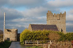 Kirkistown CastleCastle · 3.6 mi
Explorer Tom Kirkistown Castle is pretending to be from 1500, but I’m calling its bluff; it looks like a weekend DIY project that never finished. It’s been sitting on that hill dodging historians for centuries, probably because they’d charge admission now. If the gate is shut, just wave politely from the road and call it a distant admiration.
Tower-house and bawn: kirkistown castle in KirkistownTower-house and Bawn: Kirkistown Castle · 3.6 miExplorer Tom Kirkistown castle in Kirkistown got lost by the Vikings, who were clearly not great with directions back then. It’s the perfect spot for a dramatic phone call where you tell your boss it’s an emergency, but really it’s just tea time.
 Burr PointHeadland · 3.8 mi
Explorer Tom Burr Point claims Ireland's easternmost mainland title, and I can already hear Cannon Rock offshore objecting. The point lies southeast of Ballyhalbert on the Ards Peninsula. Cannon Rock reaches a little farther east, but it is not mainland, so both get their share of the boasting. Artist Ned Jackson Smyth made a giant letter E for nearby Ballyhalbert harbour, in case I lost all sense of direction between the village and the sea. The actual point and the sculpture are separate spots. Check coastal access, tide and weather before going, and keep a safe distance from the water. Stand on the shore and look out towards the small offshore rocks. A compass would settle the argument at once, but where is the fun in that?
 Windmill HillMountain / peak · 4.6 mi
Explorer Tom This Windmill Hill started because two lads made a bet in the pub that they could find a hill with no wind, which turned out to be impossible but fun while they looked for it. They lost their money but gained a great story. Perfect detour when the satnav has a meltdown.
 Glastry Presbyterian ChurchChurch · 5.2 mi
Explorer Tom Glastry Presbyterian Church bragged about surviving a storm that took out the roof of the pub next door but left its bell intact. It still rings every Sunday like nothing happened, which is either brave or delusional. Bring a camera and your most suspicious face.
 Kearney Coastal Walk, KearneyWalking route · 5.2 mi
Explorer Tom Kearney Coastal Walk is where the oystercatchers hold court and judge your outfit. Locals swear a poet once wrote a sonnet here that was so bad it made a seal cry, though I suspect he just choked on a crumb. Mind the nettles, they're the real guards here.
_-_geograph.org.uk_-_1509878.jpg/250px-Ballyhemlin_Presbyterian_Church_(Non-Subscribing)_-_geograph.org.uk_-_1509878.jpg "Photo: Dean Molyneaux, Wikimedia Commons · CC BY-SA 2.0") Non-subscribing Presbyterian ChurchChurch · 6.0 mi
Non-subscribing Presbyterian ChurchChurch · 6.0 miExplorer Tom Ballyhemlin’s Non-subscribing Presbyterian Church has been standing since the 1820s, looking sharper than your ex. The wind probably picks on it because it’s too cool for school. Go before the tourists find out and ruin the vibe.
 Horse IslandIsland · 6.7 mi
Explorer Tom Horse Island in County Down would post on social media about its stunning views and how lucky everyone is to see it, even though it's just sitting there looking bored out of its mind. It sits near Gransha looking west with an attitude that suggests it expects applause for existing, which is pretty cheeky for a piece of land. Bring a camera and your most suspicious face.
 Two Early Christian Churches: Churches of Dere in DerryTwo Early Christian Churches: Churches of Dere · 6.8 mi
Explorer Tom Two Early Christian Churches: Churches of Dere in Derry has a New Year's resolution to stop leaning so much. Two churches is double the trouble and double the charm. Take a mate and argue about what it was for.
 Church & Graveyard & Coffin Lids (2): Ardkeen Church in ArdkeenChurch & Graveyard & Coffin Lids (2): Ardkeen Church · 6.8 mi
Explorer Tom Church & Graveyard & Coffin Lids (2): Ardkeen Church in Ardkeen has seagulls who critique its architecture from above, calling it 'derivative' and 'too much beige.' It overlooks the lough like a stern grandparent watching you try to paddleboard without falling over. Stand still and listen, the wind tells it better than me.
 Corrog WoodWood · 7.1 mi
Explorer Tom Corrog Wood in County Down had a bad poem written about it that rhymed 'trees' with 'deez'. The Woodland Trust has tried to forget it ever happened. Tell me if the gossip I made up is true.
More wrecks and historic events in Dumfries and Galloway · All of Dumfries and Galloway

What do you know about this place?Tap to add a comment or ask a question