What is recorded here
Archaeologically Sensitive Area Around the Castle in Ringdufferin is an archaeologically sensitive area around the castle in County Down, Ireland.
From the Northern Ireland Sites and Monuments Record record MRD187:036
The monument record does not grant public access. Check the route and ask the landowner before entering private land.
- What survives
- Recorded monument
Places near here
Photo credits
- Bob Jones, Geograph · Creative Commons Attribution-ShareAlike 2.0
- Rossographer, Geograph · CC BY-SA 2.0
- Albert Bridge, Geograph · CC BY-SA 2.0
- Albert Bridge, Geograph · Creative Commons Attribution-ShareAlike 2.0
- Peter Clarke ( talk ) Original uploader was Peter Clarke at en.wikipedia, Wikimedia Commons · CC BY-SA 3.0
- Albert Bridge, Wikimedia Commons · CC BY-SA 2.0
- Shane Killen, Geograph · CC BY-SA 2.0
- Eric Jones, Wikimedia Commons · CC BY-SA 2.0
- Eric Jones, Geograph · CC BY-SA 2.0
 Stone quay in RinghaddyStone Quay · 1.0 mi
 Island TaggartIslet · 1.3 mi
 Dunnyneill IslandsIsland · 1.9 mi
 ShrigleyVisitor information · 2.2 mi
 Net Walk & Shore LoneyWalking route · 2.3 mi
 Stone quay in BallymorranStone Quay · 2.3 mi
 Killowen medieval church (ruined) and graveyard; with 2 cross-carved stones in Corporation (killyleagh)Killowen Medieval Church (ruined) and Graveyard · 2.3 mi
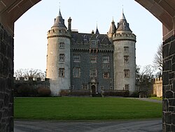 Killyleagh CastleCastle · 2.5 mi
_-_geograph.org.uk_-_3438577.jpg/250px-Killyleagh_Castle_(2013)_-_geograph.org.uk_-_3438577.jpg "Photo: Albert Bridge, Wikimedia Commons · CC BY-SA 2.0") Killyleagh CastleCountry House · 2.5 mi
Killyleagh CastleCountry House · 2.5 mi Killyleagh CastleKillyleagh castle, multiperiod castle on site of Motte · 2.5 mi
 Dufferin ArmsPublic House · 2.5 mi
 Church & Graveyard & Coffin Lids (2): Ardkeen Church in ArdkeenChurch & Graveyard & Coffin Lids (2): Ardkeen Church · 3.5 mi
More castles and forts in County Down · All of County Down
What do you know about this place?