What is recorded here
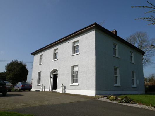
Annahean House in Annahean presents its side to the approach road despite having a grand pillared entrance. It has spent the best part of two centuries waiting for someone to say, “Will you turn round till we admire you?”
Detached three-bay two-storey L-plan house, built c.1850, having two-bay north side elevation, and with full-height return to re-entrant corner of plan at rear. Hipped slate roof with red brick chimneystacks with render eaves band, and some cast-iron rainwater goods. Wet-dashed rendered walls with smooth plinth. Square-headed window openings with patent reveals and painted stone sills, having timber sliding sash windows without horns to front and rear elevations, six-over-six pane windows to ground floor and three over-six pane to first floor front, and mixed six-over-six pane, three-over-six pane and two-over-two pane to rear elevation. Later timber sliding sash windows with six-over-six panes to side (north) elevation. Elliptical-headed door opening having flush reveals, petal fanlight, and Doric pilasters flanking timber panelled door. House located on elevated and exposed site with roofless ruinous rectangular-plan rubble stone dovecote to rear. Farmyard to south-east, having rubble stone entrance arch with wrought-iron double-leaf gate, two-bay single-storey outbuilding with pitched roof and rubble stone walls adjoining this, and three-bay two-storey outbuilding with pitched roof, rubble stone walls and square-headed openings with gauged brick surrounds, forming east edge of yard. Twentieth-century farm structures to south. Stands adjacent to site of earlier tannery and mill.
Annahean House is a typical middle-sized mid-nineteenth-century house. Its decoration is confined to the Georgian-style entrance with windows arranged symmetrically around this. The retention of early fabric adds a patina of age and enhances the character of the house. The house has an unusual relationship with the approach road by presenting its side elevation to visitors. The stone dovecote and arch are reminders of the former uses of the complex of buildings. Doves were kept for their meat, eggs, and manure. The outbuildings appear to predate the house and may have belonged to the former tannery and mill complex shown on the Ordnance Survey first edition map published in 1836.
From the Buildings of Ireland (National Inventory of Architectural Heritage) record 41403415
This does not grant access. Most recorded buildings are privately owned; view them only from public ground unless the owner allows entry.
Places near here
Flat cemetery in AnnaheanFlat cemetery · 395 ydAncient Burying GroundEcclesiastical enclosure · 511 yd Lagan BridgeBridge · 1685 ydCoolderry Chapel of EaseChurch/chapel · 1.3 miMatthew's HillMountain / peak · 3.2 miBarleyhillMountain / peak · 4.5 miMonkey-puzzle4.5 miEuropean Beech4.8 miSir Frederick Foster MemorialMemorial · 6.2 miThe College (in Ruins)College · 6.3 miCastleCastle, tower house · 6.3 miCastleCastle, tower house · 6.4 mi
 Lagan BridgeBridge · 1685 yd
 Coolderry Chapel of EaseChurch/chapel · 1.3 miMatthew's HillMountain / peak · 3.2 miBarleyhillMountain / peak · 4.5 mi
 Monkey-puzzle4.5 mi
 European Beech4.8 mi
 Sir Frederick Foster MemorialMemorial · 6.2 mi
 The College (in Ruins)College · 6.3 mi
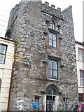 CastleCastle, tower house · 6.3 mi
 CastleCastle, tower house · 6.4 mi
Pictures: National Inventory of Architectural Heritage; Vicente Fernández Rioja, Wikimedia Commons · CC BY-SA 4.0; Malene Thyssen, Wikimedia Commons · CC BY-SA 3.0; Nuala Furley, Wikimedia Commons · CC BY-SA 4.0; Dasmuy, Wikimedia Commons · CC BY-SA 4.0; Eric Jones, Geograph · CC BY-SA 2.0
More historic places in County Monaghan · All of County Monaghan
What do you know about this place?