What is recorded here
From OpenStreetMap (© OpenStreetMap contributors) n3768685774
Places near here
Picture notes
- National Inventory of Architectural Heritage
- Kenneth Allen, Geograph · CC BY-SA 2.0
- Kenneth Allen, Wikimedia Commons · CC BY-SA 2.0
- Dr Neil Clifton, Geograph · CC BY-SA 2.0
- Computer-made picture. It does not show this playground.
- Andreas F. Borchert, Wikimedia Commons · CC BY-SA 3.0 de
- Patrice78500, Wikimedia Commons · Public domain
- Malene Thyssen, Wikimedia Commons · CC BY-SA 3.0
 Droichead na hAbhna Bige [Owenbeg Bridge]Bridge · 3.5 mi
Explorer Tom Droichead na hAbhna Bige has these really long, squinty stones in the arch that look totally different from the chunky bits holding it up. I bet they were trying to make the bridge look like it’s wearing a very fancy, crooked hat.
 Owenwee BridgeBridge · 3.6 mi
Explorer Tom Owenwee Bridge crosses the river on one broad arch, with long rock-faced stones set around its curve. Built around 1860, it looks almost as if the arch stretched each stone to fit. The rubble abutments stay plain by comparison.
 Three TopsMountain / peak · 4.5 mi
Explorer Tom Three Tops holds a long grudge against the weather for always picking on it first. The clouds hate it personally, I reckon. Take a breath of that air, it’s older than your car and smells like pure attitude.
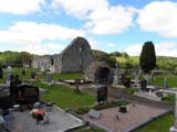 Stackarnagh Abbey GraveyardGraveyard · 5.2 mi
Explorer Tom Stackarnagh Abbey Graveyard has a gatepost detail I keep coming back to: a reused window fragment carved with a fish biting the end of a moulding, with a rough unicorn above it. The survey says the stone probably came from the church's ruined south window. I can enjoy the odd pair without inventing what the medieval carver meant.
 Wilkin's of Church HillPub · 5.5 mi
Explorer Tom Wilkin's of Church Hill in County Donegal sounds like it's guarded by an angel who demands tips. If the church bell rings, run for cover before the gossip starts.
 Children's playground5.6 miComputer-made picture. It does not show this playground.
Explorer Tom Children's playground in County Donegal is covered in leaves that look like autumn's final apology for being so messy. I bet if you dig deep enough, you'll find a coin from 1985 and instant fame. Go back in winter, it's a different animal entirely.
 MoylenanavMountain / peak · 5.7 mi
Explorer Tom Right then, folks, here’s Moylenanav, standing tall in the misty corners of County Donegal. I’m still trying to work out how to pronounce that second syllable without sounding like a startled goose, but it definitely looks like it’s got some character.
 Newmills Corn and Flax MillsHeritage attraction · 5.9 mi
Explorer Tom Newmills Corn and Flax Mills has a waterwheel big enough to make me stop and watch the machinery do the hard work. Corn and flax kept different trades moving here. Heritage Ireland's 2026 visitor season has ended, so I would check the next opening date before making the trip.
 Páirc Naisiúnta Ghleann Bheatha - Glenveagh National ParkNature reserve · 6.2 mi
Explorer Tom Glenveagh National Park is massive and moody, with Lough Veagh staring back at you like it knows all your secrets. The air smells of peat and ancient drama, perfect for feeling small in the face of nature’s indifference. Bring a coin for luck and keep it tightly in your pocket.
 Battle of ScarrifholisBattle · 6.3 mi
Explorer Tom Scarrifholis was nearly sold for a horse in 1650 because nobody could agree on the price. It’s still annoyed about that deal, honestly. Stand there long enough and someone will definitely ask if you’re lost or just having an existential crisis.
 European Beech6.3 mi
Explorer Tom European Beech in County Donegal is another one of those trees with attitude, standing tall while you try to figure out where you’re going. It’s calm, ancient, and completely unbothered by your presence. Go with someone who loves old stuff and watch them melt like butter on toast.
 Teach Tábhairne an RileánPub · 6.6 mi
Explorer Tom Teach Tábhairne an Rileán in County Donegal has a mouthful of a name. Say it three times fast for me and tell me how you feel!
More mountains and hills in County Donegal · All of County Donegal

What do you know about this place?Tap to add a comment or ask a question