
Places near here
Photo credits
- National Inventory of Architectural Heritage
- Ronan Mac Giollapharaic, Wikimedia Commons · CC BY-SA 4.0
- Kmcnamee, Wikimedia Commons · CC BY-SA 4.0
- Guilhem Boyer, Wikimedia Commons · CC BY-SA 3.0
- Tom Pullman, Wikimedia Commons · CC BY-SA 2.0
- Marathon, Geograph · CC BY-SA 2.0
- Herbert Ortner, Wikimedia Commons · CC BY 3.0
- Gordon Hatton, Wikimedia Commons · CC BY-SA 2.0
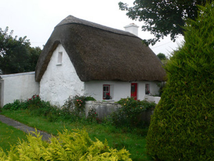 An PúcánHouse · 193 yd
Explorer Tom An Púcán in Killeany is still rocking its thatched roof like it hasn't heard about modern roofing materials, which is…
 Gairm-Sgoil ÉinneSchool · 200 yd
Explorer Tom Gairm-Sgoil Éinne in Killeany loves singing sea shanties because the wind always helps out. Its limestone walls are…
 Dún EochlaHeritage attraction · 1.3 mi
Explorer Tom Dún Eochla is in a total feud with the next village over because they keep stealing its best view for their garden…
 Arkin's CastleCastle · 1.4 mi
Explorer Tom Arkin's Castle faces the sea at Cill Éinne on Inis Mór, with the sort of address that suggests the postman should own a…
 Pairc Einne Inis Mór, clg Oileáin ÁrannGAA ground · 1.4 mi
 St. Eanys WellHoly well · 1.5 mi
Explorer Tom St. Eanys Well in Cill Éinne is a spring under stone walls that swears it was actually dug by a dragon who got tired…
 Teampall BheanáinHeritage attraction · 1.5 mi
Explorer Tom Teampall Bheanáin is so small that a grand speech might take up more room than the church itself. It stands high above…
 DoocaherPromontory fort, coastal · 1.6 mi
Explorer Tom Doocaher in Cill Éinne is sick of being asked if it’s haunted because it’s just really windy up there on that cliff…
 Seal Colony LookoutViewpoint · 2.0 mi
Explorer Tom Seal Colony Lookout was designed by a builder who thought seals needed a VIP lounge for their afternoon naps, complete…
 ÁrainnIsland · 2.5 mi
Explorer Tom Call Árainn by the map's other name and it may forgive you eventually. Árainn has been called Inishmore so often that…
 The Fir Bolg: Dún AonghasaLegend location · 4.0 mi
Explorer Tom The Fir Bolg: Dún Aonghasa has a mighty stone fort and a name tied to their leader Aonghas. If I had a fort named after…
 Dún ConchúirFort · 4.2 mi
Explorer Tom Dún Conchúir is famous for smuggling contraband that definitely wasn’t just whiskey, but rather three hundred pounds of…
More archaeology and monuments in County Galway · All of County Galway

What do you know about this place?Tap to add a comment or ask a question