DDiscover AloneMapAbout

Abbey in Athenry

Religious house, Dominican friars

What is recorded here

This Dominican priory, dedicated to Saints Peter and Paul, is located on the E bank of the Clarin River, in the NE of quarter of the medieval town of Athenry (GA084-014----). It is c. 190m to the S of the medieval castle (GA084-001006-) and c. 160m to the SE of the parish church (GA084-001005-). It occupies the SW end…

Read the whole record
This Dominican priory, dedicated to Saints Peter and Paul, is located on the E bank of the Clarin River, in the NE of quarter of the medieval town of Athenry (GA084-014----). It is c. 190m to the S of the medieval castle (GA084-001006-) and c. 160m to the SE of the parish church (GA084-001005-). It occupies the SW end of an associated graveyard (GA084-001025-). The priory was founded in 1241 by Meiler de Birmingham and received significant patronage from local Anglo-Norman and Gaelic lords. The survival of a manuscript known as the ‘Register of the Dominican Order of Athenry’, which is now housed in the British Museum but was published by Coleman (1912, 201-21), has made it possible to identify various patrons and to help trace its structural development. The church became a celebrated burial place for its founder and his descendants, as well as several bishops of Clonfert and Kilmacduagh. Thirty friars are recorded as being here in1445. The priory was granted to the Earl of Clanricard in 1568 by Elizabeth 1 and subsequently to the town of Athenry in 1574. During the latter year both it and the town were sacked by Clanricarde’s sons. In 1595 friars reoccupied the buildings but the town and priory suffered severely in the wars at the end of that century (Gwynn and Hadcock 1970, 221-2). In the 18th century it was gutted to provide materials for the military barracks that that formerly stood to its south (www.monastic.ie last accessed 22 October 2018). The barracks has since been demolished and a terrace of houses now occupies this area. The very well-preserved church is the only surviving feature of the priory; no visible surface traces of the domestic buildings or cloister survive. The church consists of the nave and chancel (int. L 45.45m; Wth 7.6m), the northern aisle and transept, and the sacristy on the south side. The site of the crossing tower between the nave and chancel is marked by the two southern piers of the arches that would have supported it. All the walls survive to their original height. The first detailed study of the church was carried out by Macalister (1913, 197-222) who suggested that there were three main building phases. The nave and chancel (int. L 45.45m; int. Wth 7.6m) were built during the initial phase of construction that started in 1241. The northern aisle and transept were added c. 1324, when reconstruction work at that time included ‘enlarging the choir twenty feet’ by knocking the original east gable and extending the north and south walls of the chancel eastwards (ibid., 201, Fig. 1). The tower was subsequently added c. 1425. Later writers including Leask (1960, 126-8) and Conlan (2002, 218-19) agreed with this phasing. A more recent survey by McKeon (2009, 24-56) argues that the aisle and transept may have been added during the late 13th or early 14th century. McKeon further suggests that the chancel was never extended to the east but that the choir was enlarged by moving the rood screen further to the W. During this phase the W gable was rebuilt. When the tower was added in the last major building phase in the 15th century, a number of windows were replaced, some doorways were blocked and the aisle arcade was reduced. No visible trace of the original W doorway that would have accessed the church survives. Both it and half of the later 14th-century four-light tracery window above it were blocked up and plastered over in the 19th century when the external gable wall was incorporated into a handball alley. The six pointed lancet windows and three wall monuments (GA084-001070-, GA084-001071- and GA084-001072-) in the S wall of the nave date to the mid-13th century and are original features. The most easterly lancet was truncated and partially blocked when the tower was built. The double piscina between the most easterly wall monument (GA084-001073-) and the tower suggests that there was formerly an altar in this area and that it was also removed when the tower was built (McKeon 2009, 39). Two blocked doorways in the S wall of the nave, one towards its W end the other in recess between the piers of the tower, would have formerly accessed the W range and cloister of the priory. The other features in the nave are later in date and include a 16th-century round-headed statue niche above a moulded and decorated consul (Bradley and Dunne 1990, 32) and a 17th-century half-hexagonal protruding feature or viewing loft. The seven lancets in the north wall of the chancel are identical to those in the nave. The westernmost example was blocked up when the transept was added. The triple-arched cusped sedilia (Wth 2.4m) is an original feature and its similar design to the wall monument (GA084-001071-) in the S wall of the nave suggested to Macalister (1913, 209) that it was another tomb niche but unlike the tomb niches its base does not extend to ground level but sits 0.5m above it (McKeon 2009, 31-3). The central columns that supported the arches and most of the moulded stones of the arches themselves have been removed. The remains of a carved head visible on the terminal of the arch hood on the W side suggest it might be that of a bishop (ibid.). Three steps subdivide the chancel, marking off the choir from the area where the high altar stood under the four-light switchline tracery east window. This window, which was inserted in the 15th or 16th century, replaced an earlier larger five-light example. The outline and fragments of the tracery of the latter window, which indicate a 13th or 14th-century date, are visible in the gable wall. At the top of the gable the lower portion of a single-light window is visible. Twin-light trefoil-headed windows at the east end of the N and S walls lit the altar area. A 15th-century canopied altar tomb (GA084-001044-) is visible in the north wall. A pointed doorway in the south wall of the choir accessed the sacristy. The latter room is lit by a triple-light ogee-headed window with a hood-moulding in the E wall. Numerous architectural fragments are now kept in it. The northern aisle was separated from the nave by an arcade of five arches, three of which survive. The original arches and those of the lateral aisle off the transept were taller and rested on circular columns. They were subsequently partially blocked up and during this phase of construction the columns were encased in the later fabric. A blocked-up pointed arch doorway is visible at the W end of the N wall of the aisle. A two-light tracery window is visible in the W wall and two similar windows survive in the north wall. Two further wall monuments (GA084-001074- and GA084-001075-) are located between the latter windows. The tracery in the eastern example is indicative of a 15th century date. Most of the tracery in the western example is gone but the surviving sections indicate it was identical to the eastern one. The main feature of the north transept is the large reconstructed four-light tracery window in the N wall. Below it a composite wall monument (GA084-00173-) spans the entire width of the wall. Macalister (1913, 203) believed this was not an architectural ornament but rather three separate ‘sepulchral monuments’. The fact that the W end of it overlies a graveslab (GA084-00176-), and the E wall of the transept was reconfigured to accommodate its E end, suggest that it was formerly located elsewhere in the nave or chancel. Two twin-light switchline tracery windows are visible in the E wall; the northern one is a modern replacement (Bradley and Dunne 1992, 33). A sketch by Bigari (Grose 1791) indicates that the blocked doorway visible below this window was open in the late 18th century. The doorway to the lateral aisle on the W side of the transept is composed of two orders and is pointed. This doorway is now the only means of accessing the church since the original west doorway was blocked up. This aisle is lit by a twin-light cusped window in the W wall. The arcade on the E side that separates it from the transept would

From the National Monuments Service (Archaeological Survey of Ireland) record GA084-001014

This remains an important historical record, but the official description says the monument is no longer visible or has been destroyed. The monument record does not grant public access. Check the route and ask the landowner before entering private land.

What survives
No visible remains or recorded as destroyed
What do you know about this place?Tap to add a comment or ask a question

What you write will be public.

Places near here

Photo credits
  • Andreas F. Borchert, Wikimedia Commons · CC BY-SA 4.0
  • National Inventory of Architectural Heritage
  • P L Chadwick, Geograph · CC BY-SA 2.0
  • Graham Horn, Geograph · CC BY-SA 2.0
  • Rryswny, Wikimedia Commons · CC BY-SA 4.0
  • Ingo Mehling, Wikimedia Commons · CC BY-SA 3.0
  • Stephan van Helden, Wikimedia Commons · CC BY-SA 4.0
  • Mike Searle, Geograph · CC BY-SA 2.0
  • Malene Thyssen, Wikimedia Commons · CC BY-SA 3.0
  • DeeEmm, Wikimedia Commons · CC BY-SA 2.0
Athenry AbbeyHeritage attraction · 5 yd

Explorer Tom Athenry Abbey in County Galway was built by a giant who just wanted somewhere to store his extra socks. The monks were too polite to ask him to move out later. Have a nosey, politely.
Abbey Row HouseHouse · 39 yd

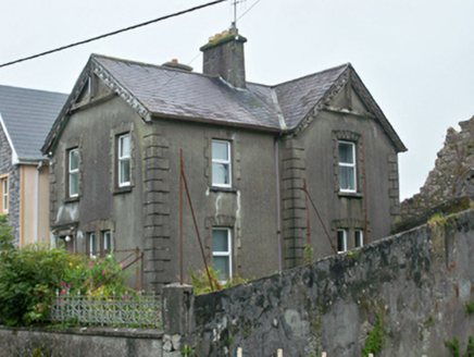
Explorer Tom Abbey Row House in Athenry is preparing to throw a nosey neighbour out with a well-timed render block and start combo. It’s got those decorative door surrounds ready for the perfect dramatic exit. Tell it a joke, it'

Ulster BankBank/financial institution · 159 yd

Explorer Tom Ulster Bank in Athenry is a fancy stone box that once held money and now holds memories. A poet fell in the ditch nearby while trying to rhyme with 'vault'. Go on a wet day, it looks best then.

Check mapCross, Market cross · 173 yd

Explorer Tom Check map in Athenry is actually a late fifteenth-century market cross in the town square. It’s been watching people haggle for centuries while pretending it doesn’t care about prices. Pretend it's yours and plan the housewarming party with local vendors.

Athenry CastleHeritage attraction · 218 yd

Explorer Tom Athenry Castle in County Galway is the favorite gossip spot for the local seagulls, who complain about the fish supply daily. They’ve been doing this since before your grandparents were born. Best visited with a curious kid and no timetable.

IndicatedTown defences · 222 yd

Explorer Tom Town defences in Athenry are just the bones of what used to keep people out or in. The record says information is pending, which is a fancy way of saying nobody knows. Linger, it's not going anywhere and neither should you.
Castle or King Johns Court (in ruins)Castle, Anglo-Norman masonry castle · 232 yd

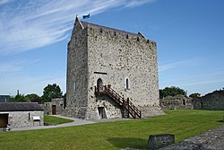
Explorer Tom Castle or King Johns Court in Athenry, County Galway was built by Meiler de Bermingham around 1235, but I suspect King John just used it for his afternoon tea. It controls a ford over the River Clareen. Bring the dog, it'll have opinions.

Horse-chestnut626 yd

Explorer Tom Horse-chestnut in County Galway ended up here because someone planted the wrong seed and then just left it alone for a century. It’s confused about its identity, so look for the ghost that supposedly haunts its branches, then pretend you didn't see anything at all.

First Battle of AthenryBattle · 1510 yd

Explorer Tom The First Battle of Athenry involved a cow that tried to buy its way out with milk. History is mostly made up by people who were hungry. Pick a stone, any stone, and invent its biography.

Castle (in ruins)Castle, tower house · 2.8 mi

Explorer Tom Castle in Castle Ellen sits right next door to the big house, looking like it forgot how to be modern. The 1838 map shows a bawn, which is just fancy talk for a fenced-in yard. Great spot to propose. Or at least to propose lunch.

European Beech8.1 mi

Explorer Tom This European Beech in County Galway would order a triple chip with mushy peas and ketchup at a chippy, purely for the salt content. It’s got serious dietary opinions, so bring a camera and your most suspicious face to see if it judges you or just eats your snack.

Knocktuagh alias Knockdoe ...Battlefield · 8.3 mi

Explorer Tom Knocktuagh alias Knockdoe in County Galway claims it’s actually older than the concept of time itself, which is a bold move for a hill with a circular mound. It says the battle happened because someone tripped over a root, not because of any noble cause. Find the date carved somewhere and feel clever; you’ll probably be wrong.

More historic places in County Galway · All of County Galway

Add to this placeAdd a picture Add a detailed tip Add a story

Explore the map1,093,392 places to discover

Next place · or swipeAthenry Abbey