What is recorded here
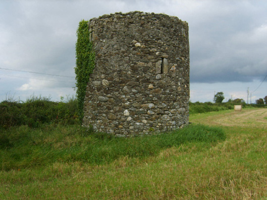
Marked on the 1839 ed. of the OS 6 inch map where it is described as a Windmill Stump. It is situated on a local height, with the NW shore of Bannow Bay c. 300m to the SE. This is a cylindrical tower (ext. diam. 4.83m; int. diam. 2.93m; surviving H 4.7m) of three storeys with opposing doorways that are damaged. There are four slit windows on the upper floors, and the upper floors were supported on corbels and rebates. A stone stairs projecting from the inner face of the wall leads from the W doorway to second floor in an anti-clockwise direction. The windmill is probably 18th century in date.
The above description is derived from the published 'Archaeological Inventory of County Wexford' (Dublin: Stationery Office, 1996). In certain instances the entries have been revised and updated in the light of recent research.
Compiled by: Michael Moore
Date of upload/revision: 22 July 2007
The monument record does not grant public access. Check the route and ask the landowner before entering private land.
- What survives
- Recorded monument
Places near here
 mill (wind)mill (wind) · 1 yd
 Field boundary in ClonminesField boundary · 840 yd
 RoadRoad, road/trackway · 1150 yd
 CastleCastle, tower house · 1313 yd
 Town defences in ClonminesTown defences · 1386 yd
 IndicatedBawn · 1461 yd
 1798 MemorialMemorial · 2.0 mi
 Carrig-On-BannowVisitor information · 2.0 mi
 Saltmills Explosion MemorialMemorial · 2.5 mi
 Bridges ChamberCave · 2.8 mi
 Blackhall StrandBeach / strand · 2.8 mi
 Ballymadder PointHeadland · 3.1 mi