Places near here
Photo credits
- National Inventory of Architectural Heritage
- DiKey, Wikimedia Commons · CC BY-SA 4.0
- Jonjobaker, Wikimedia Commons · CC BY-SA 4.0
- William Murphy from Dublin, Ireland, Wikimedia Commons · CC BY-SA 2.0
- Darrin Antrobus, Geograph · CC BY-SA 2.0
- Ianfhunter, Wikimedia Commons · CC BY 4.0
- A.-K. D., Wikimedia Commons · CC BY-SA 4.0
- Tony in dublin, Wikimedia Commons · CC BY-SA 3.0
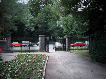 Malahide CastleDemesne walls/gates/railings · 1084 yd
Explorer Tom Another Malahide Castle entrance in Mabestown, but this one has limestone piers that look like they’re holding back a very polite crowd of ghosts. I once saw a fox try to take charge of the railings and it looked like it was conducting an invisible orchestra. Look serious, nod slowly, you're basically an expert now.
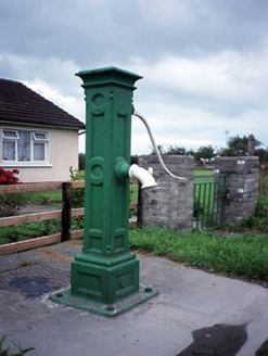 water pump1111 yd
Explorer Tom Water pump in Kinsaley is showing off its maker's mark. Tonge & Taggart Ltd., Dublin, stamped right on this square c.1900 beauty. It's got a curved handle and looks like it's ready to serve up some history.
Kinsealy CourtMemorial · 1268 ydExplorer Tom Kinsealy Court in County Dublin is the kind of place Saint Patrick would have walked into and immediately said, 'Right, that's enough, I’m going home.' It’s a memorial with a dramatic flair that makes the wind look jealous of how well it holds its shape. Perfect place to be dramatically windswept.
 Malahide Castle Demesne Church (Ruin)Ruins · 1.2 mi
Explorer Tom Malahide Castle Demesne Church is a ruin that lost its congregation long ago. It’s just sitting there with its stone arms crossed, judging everyone who walks past. Tell it the service was great last time!
 St Catherine's WellSpring · 1.6 mi
Explorer Tom St Catherine's Well in County Dublin is tucked near Malahide, which is fancy, but this well looks like it forgot to iron its shirt. It might be a wishing well for lost keys. Make a wish and keep moving!
 Casino Model Railway MuseumMuseum · 1.6 mi
Explorer Tom Casino Model Railway Museum would cope on a reality show by having its trains run through the contestants’ dreams while they sleep, forcing them to solve puzzles in miniature scale just to wake up. It’s got this intense energy where the tiny engines are screaming at full volume, which is weirdly loud for something so small and precise. Stand still and listen, the wind tells it better than me.
 Airside Retail ParkVisitor information · 1.6 mi
Explorer Tom Airside Retail Park has a New Year's resolution to stop pretending it’s an airport and just admit it’s a big car park with aspirations. It’s got that smell of hot asphalt and regret, which is basically the national scent of County Dublin if you ask me, so enjoy it while it lasts. Tell the kids it's a castle. Close enough.
 MoatCastle, motte and bailey · 1.8 mi
Explorer Tom Moat in Sainthelens is a flat-topped mound that lost a bet with a priest and now sits there looking confused because its fosse stops abruptly where the bailey used to be, which is just plain rude for a historical site. Give it a pat on the way past, it's had a long life.
 St Colmcilles WellVisitor information · 1.8 mi
Explorer Tom St Colmcilles Well has strict rules about who can drink from it, mostly because it doesn't trust anyone with a mobile phone, and if you spill a drop, it will hold it against your entire family for the next century. It's not just water; it's liquid judgment wrapped in a stone circle that smells faintly of old pennies and regret. Go with someone who loves old stuff and watch them melt.
 St. Columbs WellHoly well · 1.9 mi
Explorer Tom St. Columbs Well in Townparks would order extra vinegar and salt if it could walk into a chipper, mostly because it has spent centuries curing sore eyes for people who needed a break. It’s tucked away off the road looking like it’s waiting for St Columba to come back and collect his unpaid parking tickets. Pretend you're a lost aristocrat, nobody will check.
 Swords Round TowerHeritage attraction · 2.0 mi
Explorer Tom Swords Round Tower heritage attraction in County Dublin was saved by a hero nobody remembers anymore, who probably just tripped over a rock at the right moment to stop a falling beam from crushing it. It is the ideal place to stand around and rehearse an excuse for being late to work while looking very thoughtful.
 Round Tower2.0 mi
Explorer Tom Round Tower in Swords Glebe. This four-storey tower has a later reconstruction on top. It’s like wearing a new hat on an old head. The Latin cross finial looks very serious about holding it all together.
More archaeology and monuments in County Dublin · All of County Dublin

What do you know about this place?Tap to add a comment or ask a question