
Places near here
Photo credits
- National Inventory of Architectural Heritage
- Kmcnamee, Wikimedia Commons · CC BY-SA 4.0
- Mike Searle, Wikimedia Commons · CC BY-SA 2.0
- Kenneth Allen, Geograph · CC BY-SA 2.0
- kevin higgins, Geograph · CC BY-SA 2.0
- kevin higgins, Wikimedia Commons · CC BY-SA 2.0
- Andreas F. Borchert, Wikimedia Commons · CC BY-SA 4.0
 mill (wind)1 yd
Explorer Tom Ballyharty Mill in Wexford has a local who claims he invented it, even though the windmill tower looks like it was…
Enclosure in BallyhartyEnclosure · 229 ydExplorer Tom Enclosure in Ballyharty refuses to fall down because it knows exactly how much drama it can get away with showing off.…
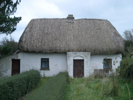 farm house687 yd
Explorer Tom Farm house in Richfield would win a county fair by showing off its mud walls. It’s made of daub and pride, standing…
 Kilmore GAAGAA ground · 1.3 miCastleCastle, unclassified · 1.4 mi
Explorer Tom Castle in Richfield would tell its younger self to stop trying so hard and just let the Devereux family deal with the…
_-_geograph.org.uk_-_3715787.jpg/250px-Castles_of_Leinster,_Ballyhealy,_Wexford_(1)_-_geograph.org.uk_-_3715787.jpg "Photo: Mike Searle, Wikimedia Commons · CC BY-SA 2.0") Castle (in ruins)Castle, tower house · 2.2 mi
Castle (in ruins)Castle, tower house · 2.2 miExplorer Tom Castle in Ballyhealy Castle claims it’s older than the Cheevers family, but really it’s just been standing there since…
St. Anne's GAA, RathanganGAA ground · 2.3 mi Kilmore Quay - Crehen Twinning MemorialMemorial · 2.7 mi
Explorer Tom Kilmore Quay - Crehen Twinning Memorial has a least favourite visitor who always tries to take pictures of the anchor…
 Cull IslandIsland · 2.7 mi
Explorer Tom Cull Island smells like wet wool and regret, according to my nose which I trust implicitly. It’s an island that only…
 Kilmore Quay Walking TrailVisitor information · 2.8 mi
Explorer Tom Kilmore Quay Walking Trail is secretly proud of a potato. It grew there once, huge as a melon, and the trail still…
 Ballyteigue BurrowNature reserve · 3.2 mi
Explorer Tom Ballyteigue Burrow runs out from Kilmore Quay as a long sweep of Wexford dunes, beach and sheltered wetland, all…
 Font in BallyconnickFont · 4.2 mi
Explorer Tom Font in Ballyconnick is stuck in the ground without a drain hole, so it’s basically holding its breath. A cow once…
More archaeology and monuments in County Wexford · All of County Wexford

What do you know about this place?Tap to add a comment or ask a question