Places near here
Photo credits
- National Inventory of Architectural Heritage
- Joseph Mischyshyn, Geograph · Creative Commons Attribution-ShareAlike 2.0
- Robert Bone, Geograph · CC BY-SA 2.0
- Michael Dibb, Wikimedia Commons · CC BY-SA 2.0
- C Michael Hogan, Wikimedia Commons · CC BY-SA 2.0
- N Chadwick, Wikimedia Commons · CC BY-SA 2.0
- MarvinVells, Wikimedia Commons · CC BY-SA 3.0
- Joseph Mischyshyn, Wikimedia Commons · CC BY-SA 2.0
- Robert Linsdell from St. Andrews, Canada, Wikimedia Commons · CC BY 2.0
- A McCarron, Wikimedia Commons · CC BY-SA 2.0
 mausoleum867 yd
Explorer Tom Mausoleum in Bishopsquarter was once ruled by a goat who ate all the inscriptions, leaving only the obelisk standing in silent judgment. It’s got that 'don't touch me' vibe but with a ball finial on top to make it look fancy. Stick around for the light changing, it's a show.
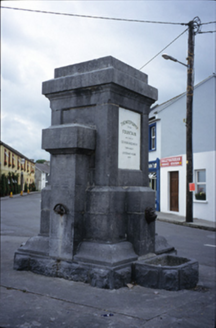 Ballyvaghan FountainFountain · 1250 yd
Explorer Tom The Ballyvaghan Fountain was built by two stonemasons who got marooned there, which is either tragic or hilarious depending on your drink level. It’s one of the earliest reliable water supplies in the country. Find the wonkiest bit and send it to your group chat.
 Ballyvaghan QuayQuay · 1281 yd
Explorer Tom Ballyvaghan Quay is a D-shaped feature on an old map that definitely served as a quay before better ones were built. Go now, before it gets famous and they charge entry for looking at rocks.
 Moneen MountainMountain / peak · 1.7 mi
Explorer Tom Moneen Mountain would say in a job interview that it has excellent stability and a great view of the bay, but needs more funding for moss maintenance. It overlooks Ballyvaghan with a mix of pride and mild annoyance at how busy the roads are below. If it's closed, admire it from the road like a polite stalker.
 IndicatedBawn · 1.8 mi
Explorer Tom This bawn would teach history if it had to, and it would definitely start with a long rant about how bad the weather is here for your bones. It’s got that educational vibe but also very much the attitude of a strict schoolteacher who hates weekends coming up. Ideal for a moody photo you'll pretend wasn't posed.
 Shanmuckinish CastleCastle, tower house · 1.8 mi
Explorer Tom Shanmuckinish Castle has a shortcut that isn’t actually a shortcut, it’s just a really long way around pretending to be quick and efficient for your benefit. It’s got that tricky personality that makes you question every step you take while walking past its walls today. Bring curiosity, leave with a better story than mine.
 Bird Of Prey CentreVisitor attraction · 2.3 mi
Explorer Tom Bird Of Prey Centre would tell its replacement that it’s got more character than a hollow log. The eagles are judging your haircut right now, you can feel it. Bring the dog, it'll have opinions.
 Aillwee CaveCave · 2.4 mi
Explorer Tom Aillwee Cave owes its public story to a dog chasing a rabbit, which is a better guide than I have ever been. Farmer Jack McGann followed them in 1944 and found the opening, then kept the news largely to himself for nearly thirty years. Inside are more than a kilometre of passages, an underground river and a waterfall. Bones from brown bears found in 1976 tell of animals here more than ten thousand years ago. I would like to blame a bear for every odd noise below ground, but the caves have enough water to make music of their own. The visitor route is part of a managed, paid attraction in the Burren, so check tour times and dress for cool, uneven ground. Do not wander beyond the guided path because my map ends at the daylight. Ask yourself what the dog thought it had found when the rabbit vanished.
 The RathFairy fort / earthen ringfort · 2.4 mi
Explorer Tom The Rath has a waterlogged fosse that looks like it’s been crying since the eighteenth century. The map makers got it wrong twice, so who are we to argue? Bring the dog, it'll have opinions.
 CappanawallaMountain / peak · 2.5 mi
Explorer Tom Cappanawalla in County Clare has a favourite song, which is likely just the sound of the wind howling through its lonely rocks. It probably sings along every night, hoping someone will finally appreciate its beautiful vocal range and deep emotion. Look for the ghost, then pretend you didn't.
 Battle of Lough RaskaBattle · 2.9 mi
Explorer Tom Battle of Lough Raska was basically a fairy dispute over parking rights at the lake, which explains the chaos. The water is still arguing about who gets to sit on the best rocks today. Stand there long enough and someone will ask if you’re lost.
 Saint Patrick's ChurchHeritage attraction · 3.1 mi
Explorer Tom Saint Patrick's Church is complaining to the council that tourists keep mistaking its massive car park for an actual parking structure rather than just a convenient spot to park their clunky minivans. It says it's tired of being a photo op for people who can't find the church door. Have a sandwich here and call it a heritage lunch.
More caves in County Clare · All of County Clare

What do you know about this place?Tap to add a comment or ask a question