
What is recorded here
From the National Monuments Service (Archaeological Survey of Ireland) record CL044-068
Places near here
Photo credits
- Maker not stated on source page, uk.pinterest.com
- National Inventory of Architectural Heritage
- Maker not stated on source page, www.flickr.com
- Maker not stated on source page, www.pinterest.com
- Maker not stated on source page, www.dreamstime.com
- Maker not stated on source page, commons.wikimedia.org
- Roger Diel, Geograph · CC BY-SA 2.0
- BBnet case study of O’Callaghan’s Mills GAA Club; individual photographer not named, www.bbnet.ie
- Maker not stated on source page, www.youtube.com
- Hywel Williams, Geograph · CC BY-SA 2.0
 Standing stone in HurdlestonStanding stone · 1.5 mi
Explorer Tom Standing stone in Hurdleston would introduce itself as ‘Just a rock, mate,’ but we all know it’s lying through its…
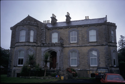 Hurdlestown HouseHouse · 2.0 mi
Explorer Tom Hurdlestown House is dated 1871 but looks like it tried to be a castle and lost the budget halfway through. It’s got…
 Kilseily Church (in Ruins)Church · 2.1 mi
Explorer Tom Kilseily Church was supposedly haunted by a fiddler who played until his fingers turned blue and brittle. This is the…
 Broadford GAA pitchGAA ground · 2.1 mi
 Ballykelly Castle (in Ruins)Castle, tower house · 2.3 mi
Explorer Tom Ballykelly Castle in Ballykelly would make Saint Patrick laugh at his own jokes if he saw it now. It’s a tower house…
 Mapped cemeteryCemetery · 3.2 mi
Explorer Tom Mapped cemetery in County Clare is locked in a bitter feud with the rain, which seems determined to wash it off the map…
 Fairy fort / ringfort in BallybrackFairy fort / ringfort · 3.7 mi
Explorer Tom Fairy fort / ringfort in Ballybrack’s first owner had an escape plan involving a rope made of grass and pure luck. It’s…
 Aharinagh Castle (in ruins)Castle, unclassified · 3.7 mi
Explorer Tom Aharinagh Castle in Ballybrack feels like it was designed by a very angry mother-in-law who hated guests. The whole…
 Ballymoloney WoodForest · 4.3 mi
Explorer Tom Ballymoloney Wood is where two families had a feud over who owned the view, which sounds like something out of a soap…
 O'Callaghans Mills GAA pitchGAA ground · 5.1 mi
 Graveyard in BallybroughanGraveyard · 5.7 mi
Explorer Tom Graveyard in Ballybroughan is playing hard to get, hiding behind a fence with no sign and a very confused landowner. I…
 Cratloe WoodsForest · 6.1 mi
Explorer Tom Cratloe Woods spreads above its Clare village as if the trees got together and decided the Shannon Estuary needed a…
More archaeology and monuments in County Clare · All of County Clare

What do you know about this place?Tap to add a comment or ask a question