
Places near here
Photo credits
- National Inventory of Architectural Heritage
- DeeEmm, Geograph · CC BY-SA 2.0
- Vanessa Kennedy, Wikimedia Commons · CC BY 2.0
- Mike Searle, Geograph · CC BY-SA 2.0
- Michael Deligan, Wikimedia Commons · CC BY-SA 4.0
- Jason Keane, Geograph · CC BY-SA 2.0
- Jan Wyk, Wikimedia Commons · Public domain
- Picture: Discover Ireland
- P L Chadwick, Wikimedia Commons · CC BY-SA 2.0
Explorer Tom Doon Hill has gaps at east and west, which is handy if you need to get out quick. There are traces of stones inside, which might be foundations or just fancy pebbles. Bring your worst joke, the place has heard worse.
 Saint Mary's Catholic ChurchChurch/chapel · 1349 yd
Explorer Tom Saint Mary’s in Ballyeighter sits right next to the road like it’s trying to catch a bus or annoy the passing traffic. It’s a simple barn church that would tell its younger self to stop being so basic and start acting more majestic, which is rich. Watch out for the limestone detailing, it’s got some serious attitude.
 Dalyston HouseGates/railings/walls · 1396 yd
Explorer Tom Dalyston House gates are locked in a permanent argument with the rain, accusing it of ruining their limestone piers and lion masks. The curved walls look like they’re about to hug you, but I suspect they’ll just slap you instead. It’s free to stare, so do it aggressively!
Stone Islands SouthIslet · 2.0 miExplorer Tom Stone Islands South was once ruled by a goat named Brian who thought he was the king of the hill. He ate all the signs and then looked at the tourists with pure disdain. It's the kind of place that makes a dull Tuesday interesting.
 Long PointHeadland · 2.1 mi
Explorer Tom Long Point in County Galway is absolutely shredding those Dublin tourists who think they know the coast. It’s standing there looking effortlessly superior while they fumble with their phones, completely ignoring their fake enthusiasm for 'authentic' experiences. Just take a moody photo and pretend you didn't pose for it.
 St. Brendans Catholic CathedralCathedral · 2.6 mi
Explorer Tom St. Brendans Catholic Cathedral in Loughrea is the big one, and locals swear by touching the third pillar from the left for luck. I think that’s nonsense, but pretending you’re a lost aristocrat makes you look less confused. Pretend you're a lost aristocrat, nobody will check.
 Raruddy Castle (in ruins)Castle, tower house · 4.2 mi
Explorer Tom Raruddy Castle in Galway is a mystery wrapped in a bush. I bet after three pints, it’d spill every dark secret of the county. Have a look and decide if I was lying about the ghosts.
 Pallas CastleCastle, tower house · 7.1 mi
Explorer Tom Pallas Castle has a ghost that’s too lazy to haunt it because the stairs are too steep. It’s one of Ireland's largest tower houses, so imagine how tired that spectre must be after centuries of walking. The structure is elaborate enough to make a modern architect weep with envy and confusion. Visit, then text me what you think. I'll pretend to read it.
 Friar's IslandIslet · 11 mi
Explorer Tom Friar's Island has a long-standing grudge with the weather; it thinks the clouds are just jealous of its solitude. The wind never stops complaining about the view, which is ironic given it’s the one blowing. Bring the dog, it'll have opinions.
.jpg/250px-Battle_of_Aughrim_by_Jan_Wyk_(cropped).jpg "Photo: Jan Wyk, Wikimedia Commons · Public domain") Battle of AughrimMajor battlefield · 12 mi
Battle of AughrimMajor battlefield · 12 miExplorer Tom Battle of Aughrim in County Galway has a prophecy that says if you sneeze here, you’ll dance with the dead, but nobody ever checks because they’re too busy fighting. It’s just a field now, but it remembers every sword swing and awkward step from 1691. Sit on a wall nearby and pretend you’re in a very dusty painting.
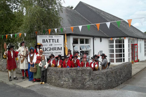 Battle of Aughrim Interpretative CentreMuseum · 12 mi
Explorer Tom Battle of Aughrim Interpretative Centre in County Galway thinks its imaginary twin across the sea is judging its display cases for being slightly too dark. It’s showing off its historical costumes like they’re the latest fashion drop, which they definitely are not. Linger a bit; it’s not going anywhere and neither should you.
 Gortaganna GraveyardGraveyard · 13 mi
Explorer Tom Gortaganna Graveyard in County Galway thinks modern houses are an affront to its dignity and ancient roots. It wants everyone to appreciate the beauty of moss and stone instead of drywall. Have a nosey, politely, so you don't offend it too much.
More archaeology and monuments in County Galway · All of County Galway

What do you know about this place?Tap to add a comment or ask a question